General M1/CT1 M2/CT2 M3/CT3 M4 M5 M6 M7 M8 M9 M10 M11 M12 M13 M14 M15 M16 M17 M18 M19 M20 M21 M22 M23 M24 M25 M26 M27 M28 M29 M30 CT4 CT5 CT6 CT7 CT8 CT9 CT12 L2 B1 B2 B3 CH1 O1 O2 Passport West Passport Central Passport East
| Map/Date | Sort: Map Date View: Current Archived Count:106 |
|---|
| ||||
| General Feb. 19, 23 | Stream Crossings: Please be aware that there are many fords along the Finger Lakes Trail System. Stream beds may be completely underwater, so you have to walk on the bottom of the creek, which may be very slick stone; or you may want to try to step from one rock to another above (or partially above) the water, and the rocks may be wobbly and are likely to be very slippery, too. Or, drought may have made the earth unable to absorb run-off from sudden heavy downpours. These natural conditions can change every year, with flooding, summer growth, and use. We strongly advise you to use hiking poles or sticks when fording creeks. These are extremely useful when descending into ravines or navigating other natural conditions along the trail and can be used for flicking branches off the trail, as well; so we recommend using poles/sticks any time, everywhere along the FLT System. Use good judgment; err on the side of safety; do NOT ford when water is high, fast, or dirty with debris -- return to road crossing and use high water bypass routes. - Lynda Rummel | |||
| General Jul. 4, 21 | Please, please, PLEASE DO NOT stray from the trail, do not camp or build campfires or cooking/cook-out fires along the trail, and keep your dog on-leash, when the trail is on private land. Our private landowners have granted permission only for a skinny footpath and a narrow corridor across their lands. Please mind your manners: stay away from buildings, machinery, and animals; close gates behind you if you found them closed, leave gates open behind you if you found them open; and remember that some landowners actively farm and/or hunt their lands. Please respect the wishes of our private landowners who generously allow the trail to cross their lands. Failure to do so could lead to loss of permission and hikers having to endure a roadwalk and/or our volunteers having to reroute and build new trail. - Trail Notices | |||
| ||||
| M1/CT1 Apr. 28, 22 | Map Revision: Map M1 has been brought up to date and improved in various ways. The FLT route has not changed. The main changes are:
a) Mileages on the back of the PDF now start with 0.0 at the NY/PA border. The M01 GPX track now also starts at the NY/PA border. This is in line with changes previously made on the interactive map and front of the PDF to clarify that the western terminus of the FLT is at the border. b) The map now notes the seasonal nature of parking at Access 2 (Wolf Run Rd) and Access 5 (ASP 1). Special thanks to the thru-hiker who reported this issue to [email protected]. c) The “orange” and “blue” trails leading to the Park Administration Building from Access 6 and Access 7 are now shown as non-FLT park trails. Both are marked as ASP Trail #10 Conservation Trail. d) Better descriptions of various waypoints on the interactive map. Both the PDF and GPX versions have been updated. The new Rev Date is 4/28/2022. - Jo Taylor, FLTC Mapping | |||
| ||||
| M2/CT2 Apr. 3, 24 | Hunting Closure: When: May 1, 2024 thru May 31, 2024 October 1, 2024 thru January 1, 2025 Where: Sawmill Run Rd, Access 3 (mile 10.8) to Bucktooth State Forest (mile 12.2) Bypass: North on Bucktooth Run Rd (1.3 miles) -> north on East Branch Bucktooth Run Rd (2 miles) to rejoin the trail. Note: The trail remains open within Bucktooth State Forest. It can be accessed from West Branch Bucktooth Run Rd for out and back hikes. Stay on the trail and wear blaze orange during this time. When: May 1, 2024 thru May 31, 2024 Where: Bucktooth State Forest (mile 15.8) to East Branch Bucktooth Rd, Access 5 (mile 16.3) Bypass: North on Bucktooth Run Rd (1.3 miles) -> north on East Branch Bucktooth Run Rd (2 miles) to rejoin the trail. Note: The trail remains open within Bucktooth State Forest. It can be accessed from West Branch Bucktooth Run Rd for out and back hikes. Stay on the trail and wear blaze orange during this time. Respect landowner wishes by not trespassing on sections that are closed during hunting seasons. - RTC Maria Cooper by Aaron Keller - FLTC Mapping | |||
| ||||
| M3/CT3 Apr. 3, 24 | Hunting Closure: When: May 1, 2024 thru May 31, 2024 October 1, 2024 thru January 1, 2025 Where: NY 242, Access 6 (mile 11.1) to Ellicottville / Maples Rd (CR 13), Access 7 (mile 14.5) Bypass: East on NY 242 (0.6 miles) -> north on Jefferson St (0.1 mile) -> north on Elk St (0.2 miles) -> north on Mechanic St / Maples Rd (2.2 miles) to rejoin the trail Fall Bypass: East on NY Rt 242, Access 6 (5.3 miles) -> north on NY Rt 240 (1.6 miles) to rejoin the trail (Use Caution, Busy Roads) When: October 1, 2024 thru January 1, 2025 Where: Poverty Hill Rd, Access 8 (mile 16.1) to US 219, Access 9 (mile 17.8) Bypass: East on NY Rt 242, Access 6 (5.3 miles) -> north on NY Rt 240 (1.6 miles) to rejoin the trail (Use Caution, Busy Roads) When: May 1, 2024 thru May 31, 2024 Where: US 219, Access 9 (mile 17.8) to Irish Hill Rd, Access 10 (mile 20.4) Bypass: South on US 219 (1.9 miles) -> east on NY Rt 242 (1.9 miles) -> north on Irish Hill Rd (2.2 miles) to rejoin the trail Fall Bypass: East on NY Rt 242, Access 6 (5.3 miles) -> north on NY Rt 240 (1.6 miles) to rejoin the trail (Use Caution, Busy Roads) When: October 1, 2024 thru January 1, 2025 Where: Irish Hill Rd, Access 10 (mile 20.4) to Fancy Tract Rd, Access 12 (mile 23.2) Bypass: East on NY Rt 242, Access 6 (5.3 miles) -> north on NY Rt 240 (1.6 miles) to rejoin the trail Respect landowner wishes by not trespassing on sections that are closed during hunting seasons. - RTC Maria Cooper by Aaron Keller - FLTC Mapping | |||
| M3/CT3 Aug. 1, 23 | Hiker Notice: InformationalA magic carpet ski lift has been installed across the trail. Where: HoliMont, near base of the slope (mile 10.75) The lift and underlying berm obscure the view of blazes from both directions. Trail users can proceed around either side of the lift. Take caution around the ditch surrounding the eastern side of and when ascending/descending the loose berm material. The Foothills Trail Club is working to provide a re-route and updated blazing around it. UPDATE: 07/31/2023 The flagging is being converted to blazes but is not yet completed.
- Mark Valites, FLTC Mapping - Mark Valites | |||
| M3/CT3 Apr. 18, 23 (Temporary) | Hiker Notice: Trail Work in ProgressTrail work has begun that includes rerouting, trail clean up, and replacing an old ladder Where: Switchbacks west of US-219 (mile 17.2) to Access 9 at US-219 (mile 17.8) Reroute: After traveling north along the obvious ridge, turn right and follow the orange tape to the newly constructed stairs. At the bottom of the hill make a sharp left and follow white painted blazes across the creek to Access 9, US-219. Note: It may be necessary to use fallen trees when crossing the creek in high water. - RTC Maria Cooper by Aaron Keller - FLTC Mapping | |||
| ||||
| M4 Apr. 3, 24 | Hunting Closure:
When: May 1, 2024 thru May 31, 2024 Where: Fancy Tract Rd (mile 0.7) to South Canada Hill Rd (mile 2.5) Bypass: East on Fancy Tract Rd (0.8 miles) to intersection with South Canada Hill Rd. South on Fancy Tract Rd for the main FLT. Go north on South Canada Hill Rd for the Conservation Trail. When: May 1, 2024 thru May 31, 2024 Where: Fancy Tract Rd (mile 3.0) to Cobb Blue Trail (mile 3.6) Bypass: South on Fancy Tract Rd (0.8 miles) -> East on NY Rt 242 (0.6 miles) to rejoin the trail When: May 1, 2024 thru May 31, 2024 Where: Main trail intersection with the Cobb Blue Trail (mile 3.6) to NY Rt 242 (mile 4.3). This includes the entire Cobb Blue Trail (Cobb Property) in between. Bypass: South on Fancy Tract Rd (0.8 miles) -> East on NY Rt 242 (0.6 miles) to rejoin the trail When: May 1, 2024 thru May 31, 2024 Where: Bakerstand Rd (mile 9.25) to Bear Creek State Forest (mile 10) Bypass: West on Bakerstand Rd (0.1 miles) -> North on Rogers Rd (0.75 miles) -> East on Bear Creek Rd (0.15 miles) -> North on Bear Creek Rd (0.45 miles) -> East 1 mile on Upper Bear Creek Rd to rejoin the trail. Note: The FLT in Bear Creek State Forest is not closed during hunting season. You may hike the FLT until reaching the southern boundary of the State Forest. Then you must turn around and return to the trailhead. Wear blaze orange, stay on the trail, leave dogs at home. Respect landowner wishes by not trespassing on sections that are closed during hunting seasons. - RTC Maria Cooper by Aaron Keller - FLTC Mapping | |||
| M4 Feb. 10, 24 (Temporary) | Hiker Advisory: Caution - Logging in Progress Trail Open!Where: Cobb Property mile 3.0 to mile 4.3 When: February 10, 2024 thru March 1, 2024 Over the next few weeks there will be logging occurring on the Cobb Property. The trail will remain open, just use caution through the area. There should be minimal impact to the trail. - RTC Josh Konovitz by Aaron Keller - FLTC Mapping | |||
| M4 Oct. 19, 23 (Temporary) | Hunting Closure: Fall and Spring hunting closure
When: May 1, 2024 thru May 31, 2024 Where: Bakerstand Rd (Mile 9.3) to Bear Creek State Forest southern boundary (Mile 10). Bypass: West on Bakerstand Rd (400ft), North on Rogers Rd (0.75mi), NorthEast on Bear Creek Rd (0.15mi), North on Upper Bear Creek Rd (0.45mi), East on Upper Bear Creek Rd (1mi) to rejoin FLT on road walk. Note: The FLT in Bear Creek State Forest is not closed during hunting season. You may hike the FLT until reaching the southern boundary of the State Forest. Then you must turn around and return to the trailhead. Wear blaze orange, stay on the trail, leave dogs at home. - R. Hopkins, FLT IT/Mapping | |||
| M4 Jun. 3, 23 (Temporary) | CLOSED Trail Closed by LandownerWhen: Apr 22, 22 until further notice. Where: NY16 & NY98 (mile 13.4) to Kingsbury Hill Rd (mile 16.6). Bypass: N then E on Route 98 (3.1 miles) -> rejoin FLT roadwalk NE at NY98 & Kingsbury Hill Rd (mile 1.2 on map M5). Note: Closure is due to landowner change. Parking at (M4 Access 4/M5 Access 1) is SW on Kingsbury Hill Rd (1.1 miles). - David Malinowski, RTC | |||
| ||||
| M5 Dec. 4, 17 | This caution is for all who hike during big game season, but specifically for those who hike on/near Harwood Haven Campground and tree farm (new pink-blazed section of trail): On private lands, hikers who don't advertize their presence by wearing blaze orange may be mistaken for trespassing hunters and so may inadvertantly motivate the landowner to close the trail. For your own safety/health and the continuity of the trail, if you are going to hike during big game season, wear blaze orange. Do this even if you are going out with a group of hikers -- everyone should be wearing blaze orange! Wear an international orange jacket or vest (hunting vests are great since they are cheap, light, and have lots of pockets) and hat. Dress your dog in an orange coat or vest and keep him/her on a leash, even on state forest grounds. Remember that you and the trail are guests on the land, so hike quietly, respect the landowner's right to hunt, do not stray from the trail, in your thoughts, thank the landowner for allowing you to hike across his/her property, and wear blaze orange! Please do not jeopardize our permission! - Lynda Rummel | |||
| M5 Dec. 1, 15 | ATTENTION HIKERS! During hunting season between Access 1 on Kingsbury Hill Road and Bush Hill State Forest, you may encounter authorized hunters, many of whom may be landowners, on the trail. Wear high visibility clothing, do not stray from the trail, keep dogs on a leash, and keep conversation and noise to a minimum. - Steve Catherman/Marty Howden | |||
| ||||
| M6 Apr. 3, 24 | Hunting Closure: When: October 1, 2024 thru January 1, 2025
Where: Higgins Rd (mile 2.3) to Centerville - Hume Rd / CR 3 (mile 5.0) Bypass: South on Higgins Rd (0.2 miles) -> northeast on Stickles Rd (1.1 miles) -> east on Centerville - Hume Rd (0.6 miles) to rejoin the trail When: October 1, 2024 thru January 1, 2025 Where: NY Rt 19 (mile 7.0) to Camp Rd, Access 5 (mile 11.7) Bypass: North on NY Rt 19 (1.3 miles) -> east on Rice Rd (0.8 miles) -> south on Lapp Rd (0.1 mile) -> east on Pond Rd (0.8 miles) -> north on Armison Rd (1.5 miles) -> north on Camp Rd (0.3 miles) to rejoin the trail Respect landowner wishes by not trespassing on sections that are closed during hunting seasons. - RTC David Malinowski by Aaron Keller - FLTC Mapping | |||
| M6 Feb. 9, 24 | Map Revision: Updated to show two reroutes between Higgins Rd and Centerville-Hume Rd (CR-3) and to update parking information in this section of M6.
- Jo Taylor, FLTC Mapping | |||
| ||||
| M7 Apr. 3, 24 | Hunting Closure: When: May 1, 2024 thru May 31, 2024 October 1, 2024 thru January 1, 2025 Where: Pennycook Rd (mile 3.8) to Short Tract Rd, Access 2 (mile 5.5) Bypass: East on Robinson Rd (1.2 miles) -> north on Short Tract Rd (0.2 miles) to rejoin the trail at Access 2 Respect landowner wishes by not trespassing on sections that are closed during hunting seasons. - RTC Peter Wybron by Aaron Keller - FLTC Mapping | |||
| M7 Nov. 20, 23 | Map Revision: A minor reroute west of access 2 allowed the off-road trail to be reopened with fall and spring hunting closures. A larger reroute west of access 3 replaces the road walk on Cheese Factory and Rt 24, with the road walk acting as a high water bypass when needed.
| |||
| ||||
| M8 Apr. 3, 24 | Hunting Closure: When: May 1, 2024 thru May 31, 2024 October 1, 2024 thru January 1, 2025 Where: Fox Hill Rd, Access 1 (mile 0.0) to NY Rt 70, Access 3 (mile 4.3) Bypass: South on Fox Hill Rd (0.3 miles) -> east on Snyder Rd (0.6 miles) -> east on Delude Rd (1.5 miles) -> northeast on Chautauqua Hollow Rd (0.1 mile) -> southeast on NY Rt 70 (1.3 miles) to rejoin the trail When: November 2, 2024 thru December 8, 2024 Where: Gates Rd, Access 6 (mile 12) to Friener Rd (mile 13.8) Bypass: Northeast on CR 15B (0.1 mile) -> east on NY Rt 70 (1.8 miles) -> south on Friener Rd (2.6 miles) to rejoin the trail ***Note: Bossard’s Cabin, along this section, is closed as well during these dates*** Respect landowner wishes by not trespassing on sections that are closed during hunting seasons. - RTC Peter Wybron by Aaron Keller - FLTC Mapping | |||
| M8 Feb. 14, 23 | Map Revision: M08 has been updated to reflect a reroute on the Robinson Loops orange trail and a change in parking information for Access 6 (CR 15B/Gates Rd). The nearest parking to Access 6 is 0.2 miles south on Gates Rd (pull-off parking for 3 or 4 cars). Both the PDF and GPX versions have been revised. The revision date on the PDF map remains 9/30/2022. - Jo Taylor, FLTC Mapping (Peter Wybron, RTC) | |||
| ||||
| M9 Apr. 3, 24 | Hunting Closure: When: October 1, 2024 thru January 1, 2025
Where: Webbs Crossing Rd, CR 66 (mile 17.8) to Shawmut trail junction (mile 19.2) Bypass: Northeast on Webbs Crossing Rd to rejoin the trail at Access 10 Respect landowner wishes by not trespassing on sections that are closed during hunting seasons. - RTC Peter Wybron by Aaron Keller - FLTC Mapping | |||
| M9 Nov. 22, 23 | Map Revision: A new hunting closure was added between Webbs Crossing Rd and the railroad tracks.
| |||
| ||||
| M10 Apr. 3, 24 | Hunting Closure: When: October 1, 2024 thru December 17, 2024
Where: Turnpike Rd (mile 8.2) to Wind Fall Rd (mile 9.5) Bypass: West on Turnpike Rd (0.7 miles) -> south on Cunningham Creek Rd (1.6 miles) -> east on Mehlenbacher Rd / Wind Fall Rd (1.5 miles) to rejoin the trail Respect landowner wishes by not trespassing on sections that are closed during hunting seasons. - RTC Peter Wybron by Aaron Keller - FLTC Mapping | |||
| M10 Nov. 22, 23 | Map Revision: The trail was rerouted between Middle Rd and Smith Rd to avoid an uneven walk along the field edge.
| |||
| ||||
| M11 Apr. 3, 24 | Hunting Closure: When: October 1, 2024 thru December 8, 2024
Where: Buena Vista Towlesville Rd / CR 69 (mile 3.7) to Gay Gulf Rd (mile 5.0) Bypass: Southwest on Buena Vista Towlesville Rd (1.2 miles) -> east on Turnpike Rd (0.2 miles) -> northeast on McChesney Rd (0.3 miles) -> northeast on Robinson Rd (0.9 miles) -> north on Gay Gulf Rd (0.4 miles) to rejoin the trail Respect landowner wishes by not trespassing on sections that are closed during hunting seasons. - RTC Peter Wybron by Aaron Keller - FLTC Mapping | |||
| M11 Jan. 3, 24 | Map Revision: This minor revision includes a change to the M10 track west of the start of the M11 track. Minor clarifications and updates to the back of the map and improved consistency between the online interactive and pdf maps. - April Miller | |||
| ||||
| M12 Apr. 3, 24 | Hunting Closure: When: October 1, 2024 thru December 17, 2024 Where: East of Sandpit Rd, Access 1 (mile 0.0) Private land East of Access 1 Bypass: Follow Sandpit Rd (0.4 miles) -> south on Snyder Hill Rd / Maple Heights Rd (0.6 miles) -> east on Charles St (0.2 miles) -> south on Kingsley St (0.1 mile) -> east on Whiting St (0.2 miles) -> north on Robie St -> east on Maine St (0.2 miles) -> north on Haverling St / Mitchellsville Rd / CR13 (1.5 miles) to the Hammondsport / Bath KOA resort. Take the blue blazed trail northwest (0.9 miles) to rejoin the trail. When: November 2, 2024 thru December 17, 2024 Where: Ferris Rd, Access 3 (mile 4.9) to Bristol Hills Branch Trail (mile 5.2) Bypass: West on Ferris Rd (0.1 mile) -> north on Harrisburg Hollow Rd (0.5 miles) -> east on the Bristol Hills Branch trail (0.5 miles) to rejoin the main FLT trail. When: November 16, 2024 thru January 1, 2025 Where: Mitchellsville Rd, Access 5 (mile 7.6) to CR 88 (mile 10.0) Bypass: North on Mitchellsville Rd / CR13 (0.3 miles) -> (0.1 mile) on Two Rod Rd -> southeast on Mitchellsville Hill Rd / CR89 (2.0 miles) -> south on Pleasant Valley Rd / CR88 (0.5 miles) to rejoin the trail. When: November 1, 2024 thru January 1, 2025 Where: Triad Trail mile 1.1 to mile 1.2 Bypass: West on Rt 54 -> south on Back Valley Rd -> southeast on Winding Stair Rd to rejoin the trail Respect landowner wishes by not trespassing on sections that are closed during hunting seasons. - RTC Bill Meehan by Aaron Keller - FLTC Mapping | |||
| M12 Jun. 19, 23 | Map Revision: Map M12 has been updated to use the new hunting closure styles and improve consistency between the PDF and interactive/GPX maps. Both the PDF and GPX versions have been updated. The map Revision Date is now 6/19/2023. RTC Peter Wybron by April Miller FLTC Mapping - April Miller | |||
| ||||
| M13 Dec. 23, 23 (Temporary) | Hiker Notice: Road / Bridge ConstructionWhere: Aulls Rd between mile 6.3 and 6.5 When: Estimated culvert completion possibly April 2024 Note: It has been conveyed that the water here is usually a trickle and can be crossed on foot. PLEASE assess the situation before attempting to cross. Recent rain will cause higher water levels. There is a bypass available if its needed. Bypass: Southeast on Dumack Rd -> west on CR 226 to rejoin the trail at Aulls Rd - RTC Bill Meehan by Aaron Keller - FLTC Mapping | |||
| M13 Oct. 3, 23 (Temporary) | CLOSED Trail Closed: Logging ActivityWhen: Until possibly May 2024 Where: Sexton Hollow Rd, Access 5 (mile 13.7) to Corbett Hollow Rd (mile 15.9) Bypass: Southeast on Sexton Hollow Rd -> north on Corbett Hollow Rd to rejoin the trail at the end of Corbett Hollow Rd Note: Public are allowed on Corbett Hollow Rd. There are signs saying no entry but you are permitted to stay on the road through the private land into the State Forest. This road is a dirt road that can get very muddy, washed out or flooded. There is no parking or place to turn around until you get to the state forest land at the end. - RTC Bill Meehan by Aaron Keller - FLTC Mapping | |||
| M13 Oct. 23, 18 | Hiker Notice: Road Open Despite Yosemite SamWhere: Corbett Hollow Rd / Trail mile 15.9 Public Travel is Permitted! Somewhat intimidating signs prohibiting travel up Corbett Hollow on Corbett Hollow Rd are still in place. Despite the presence of Yosemite Sam and his posse of signs, the public IS permitted to drive through to the circle turnaround in Goundry Hill State Forest at the upper end of the hollow. However, when traveling through the area between the nasty signs and Goundry Hill SF, stay on the road and do not park on the shoulder. Once inside the yellow painted and signed boundaries of Goundry Hill SF you may park your car at the side of the road (just leave room for a vehicle to get past). You may camp as usual, as long as the site is away from water (stream or run-off creek) and not close to the FLT. The obnoxious private signs are still up because they are posted on private land. There is a public ROW over the road, established in the landowners’ deed and re-established through court action taken by the state. - Aaron Keller - FLTC Mapping | |||
| ||||
| M14 Aug. 30, 23 | Map Revision: Hunting Standardization, Revision Date 8/14/2023
The front and back of the map were updated to reflect that hunting closure dates are now found on the Trail Conditions page and hunting closures are now highlighted directly on the track with red instead of using arrows. The trail itself did not change. - April Miller FLTC Mapping | |||
| ||||
| M15 Apr. 3, 24 | Hunting Closure: When: November 2, 2024 thru January 1, 2025
Where: Creek crossing (mile 2.3) to Jolly Rd, Access 3 (mile 2.7) Bypass: North on NY Rt 414 (0.3 miles) to rejoin the trail Note: The FLT from Route 414 (mile 1.7) to the stream crossing (mile 2.3) is open for an out and back hike with 300 ft of elevation gain/loss. However that section is used for hunting and you must wear blaze orange, stay on the trail, and keep dogs on short leash. When you get to the stream crossing, you must turn around and return to Route 414. When: May 1, 2024 thru May 31, 2024 Where: Satterly Hill Rd, Access 4 (mile 6.3) to Finger Lakes National Forest (mile 7.8) Bypass: North on Satterly Hill Rd (1.1 miles) to rejoin the trail When: October 1, 2024 thru January 1, 2025 Where: South Hill Rd, Access 9 (mile 13.3) to Texas Hollow Rd, Access 10 (mile 14.7) Bypass: East on CR 79 (0.3 miles) -> southeast on Texas Hollow Rd (1.0 mile) to rejoin the trail Respect landowner wishes by not trespassing on sections that are closed during hunting seasons. - RTC David Priester by Aaron Keller - FLTC Mapping | |||
| M15 Aug. 30, 23 | Map Revision: Hunting Standardization, Revision Date 8/14/2023
The front and back of the map were updated to reflect that hunting closure dates are now found on the Trail Conditions page and hunting closures are now highlighted directly on the track with red instead of using arrows. The trail itself did not change. - April Miller FLTC Mapping | |||
| ||||
| M16 Apr. 3, 24 | Hunting Closure: When: November 16, 2024 thru December 17, 2024
The entire preserve is closed to all persons except permitted hunters.
Where: Stevenson Nature Preserve of the Finger Lakes Land Trust, (mile 12.2 to mile 12.8).
Bypass: Do not enter the preserve, stay on Trumbulls Corners Road.
Note: From October 1, 2024 thru November 15, 2024, active bow hunting by permitted hunters is in progress. The trails are open to hikers during this time. You must stay on the trail, wear blaze orange, and keep your dog at home or on a short leash.
Respect landowner wishes by not trespassing on sections that are closed during hunting seasons.
| |||
| ||||
| M17 Apr. 3, 24 | Hunting Closure: When: January 13, 2025 thru January 31, 2025
Where: NY Rts 13/34/96 (mile 0.0) to Townline Rd (mile 1.5) Note: The trail through Tapan Mitra and Sweedler Nature Preserves is closed while permitted gun hunting is underway in this deer management focus area. When: October 1, 2024 thru January 1, 2025 Where: Townline Rd / Layen Rd (mile 3.2) to Comfort Rd (mile 7.3) Bypass: East on Layen Rd (0.6 miles) -> south on Jersey Hill Rd (1.1 miles) -> east on Gunderman Rd (0.8 miles) -> south on Comfort Rd (1.1 miles) to rejoin the trail When: May 1, 2024 thru May 31, 2024 Where: Bruce Hill Rd (mile 4.7) to Comfort Rd (mile 7.3) Bypass: East on Bruce Hill Rd (0.6 miles) -> east on Gunderman Rd (0.8 miles) -> south on Comfort Rd (1.1 miles) to rejoin the trail When: October 1, 2024 thru January 1, 2025 Where: Buttermilk Falls Spur Trail from junction with Thayer Blue trail (mile 0.3) to West King Rd (mile 0.8) Bypass: Take blue spur (mile 0.1) to Sandbank Rd and go east (0.5 miles) -> south on West King Rd (0.2 miles) to rejoin the orange trail Respect landowner wishes by not trespassing on sections that are closed during hunting seasons. - RTC David Priester by Aaron Keller - FLTC Mapping | |||
| M17 Sep. 7, 23 | Map Revision: Hunting Standardization
The front and back of the map were updated to reflect that hunting closure dates are now found on the Trail Conditions page and hunting closures are now highlighted directly on the track with red instead of using arrows. Updates were also made to improve consistency between the PDF and interactive/GPX maps. The trail itself did not change. Both the PDF and GPX versions have been updated. Revision Date 9/07/2023 - April Miller by Aaron Keller - FLTC Mapping | |||
| M17 Nov. 22, 22 | Map Revision: M17 was updated to remove the hunting bypass at the eastern end of the map due to updates on M18. Refer to M18 to see the new bypass on Eastman Hill Rd. The new revision date is 2022-11-17.
- April Miller, FLTC Mapping | |||
| ||||
| M18 Apr. 9, 24 (Temporary) | CLOSED Trail Closed: Gate Blocking the TrailWhere: 76 Road (mile 10.2) to Level Green Road (mile 12.1) The FLT path is currently blocked by a gate. The trail management team is trying to resolve this but in the mean time please avoid this stretch of trail. The trail section is signed at both ends. Please respect the land owners' property and do not hike here until there is a resolution to the gate. Bypass: Northwest on 76 Rd (0.9 miles) -> northeast on Yaple Rd (1.2 miles) -> southeast on Level Green Rd (1.2 miles) to rejoin the trail - David Priester Watkins-East RTC | |||
| M18 Apr. 3, 24 | Hunting Closure: When: November 16, 2024 thru December 17, 2024
Where: Eastman Hill Rd (mile 0.0) to Coddington Rd (mile 2.4) Bypass: South on Eastman Hill Rd (1.7 miles) -> southeast on Ithaca Rd (1.0 mile) -> east on Willseyville Rd (0.3 miles) -> north on Coddington Rd (1.9 miles) to rejoin the trail When: October 1, 2024 thru January 1, 2025 Where: 76 Rd / CR 115 (mile 10.2) to Potato Hill State Forest (mile 11.3) Bypass: Northwest on 76 Rd (0.9 miles) -> northeast on Yaple Rd (1.2 miles) -> southeast on Level Green Rd (1.2 miles) to rejoin the trail When: May 1, 2024 thru May 31, 2024 Where: From view point (mile 13.6) to Slaterville Rd / NY Rt 79 (mile 15.7) Bypass: West on Blackman Hill Rd (1.1 miles) -> northwest on Level Green Rd (1.9 miles) -> east on Slaterville Rd (0.9 miles) to rejoin the trail Respect landowner wishes by not trespassing on sections that are closed during hunting seasons. - RTC David Priester by Aaron Keller - FLTC Mapping | |||
| M18 Sep. 7, 23 | Map Revision: Hunting Standardization
The front and back of the map were updated to reflect that hunting closure dates are now found on the Trail Conditions page and hunting closures are now highlighted directly on the track with red instead of using arrows. Updates were also made to improve consistency between the PDF and interactive/GPX maps. The trail itself did not change. Both the PDF and GPX versions have been updated. Revision Date 9/07/2023 - April Miller by Aaron Keller - FLTC Mapping | |||
| M18 Oct. 31, 22 | Map Revision: The trail between Eastman Hill Rd and Coddington Rd has been rerouted to its new home on the Eberhard preserve. Both the pdf and gpx have been updated. The new revision date is 10-28-2022
| |||
| ||||
| M19 Apr. 3, 24 | Hunting Closure: When: May 1, 2024 thru May 31, 2024 October 1, 2024 thru December 25, 2024 Where: Mile 3.7 to Mile 4.6 Bypass: East on E Lake Rd / CR 157 (0.5 miles) -> east on Willow Crossing (0.1 mile) -> north on Daisy Hollow Rd (1.3 miles) to rejoin the trail Respect landowner wishes by not trespassing on sections that are closed during hunting seasons. - RTC David Priester by Aaron Keller - FLTC Mapping | |||
| M19 Aug. 30, 23 | Map Revision: Minor Reroute, Revision Date 8/14/2023
Where: mile 10.9 of the main trail near Bleck Rd M19 and VML (Virgil Mountain Loop) maps have been updated to reflect a minor reroute at mile 10.9 of the main trail near Bleck Rd to access a new bridge with the added benefit of making the road crossing easier. The maps have also been updated to use the new hunting closure standards.
| |||
| ||||
| M20 Apr. 3, 24 | Hunting Closure: When: September 15, 2024 thru January 1, 2025
Where: Snyder Hill Rd (mile 4.2) to West River Rd (mile 5.4) Bypass: North on Snyder Hill Rd -> east on Stafford Rd -> south West River Rd to rejoin the trail Respect landowner wishes by not trespassing on sections that are closed during hunting seasons. - RTC Peter Dady by Aaron Keller - FLTC Mapping | |||
| M20 Nov. 22, 23 | Map Revision: The trail was rerouted east of Hoxie Gorge State Forest due to change of land ownership and loss of permission.
| |||
| ||||
| M21 Apr. 3, 24 | Hunting Closure: When: October 1, 2024 thru January 1, 2025
Where: Mile 7 to Mile 7.8 Bypass: Northwest on Taylor Valley Rd (2.2 miles) -> northeast on Cheningo Solon Pond Rd (3.7 miles) to rejoin the trail Respect landowner wishes by not trespassing on sections that are closed during hunting seasons. - RTC Peter Dady by Aaron Keller - FLTC Mapping | |||
| M21 Sep. 7, 23 | Map Revision: Hunting Standardization
The front and back of the map were updated to reflect that hunting closure dates are now found on the Trail Conditions page and hunting closures are now highlighted directly on the track with red instead of using arrows. Updates were also made to improve consistency between the PDF and interactive/GPX maps. The trail itself did not change. Both the PDF and GPX versions have been updated. Revision Date 9/07/2023 - April Miller by Aaron Keller - FLTC Mapping | |||
| M21 Nov. 22, 22 | Map Revision: M21 was updated today primarily to reflect a MAJOR and very welcome reroute on M22 made possible by the hard work of numerous volunteers from the ADK Onondaga Chapter and the FLTC and by the strategic purchase of a key piece of property, enabled by the support of members of the FLT Forever Society and donors to the Sidote Trail Preservation Society. This reroute eliminates a 3.2-mile roadwalk on Cuyler Hill and Lincklaen Roads. From the intersection of O1 and the main FLT near Stoney Brook Rd, the white-blazed main FLT on M22 continues north and then east to Chippewa Falls and beyond.
Various minor changes were also incorporated into M21. Please note that hunting closure near W Keeney Rd on O1, also shown on M21, has been corrected. It extends from Nov. 15 to Jan. 1. The new revision date is 2022-11-15. - Jo Taylor, FLTC Mapping | |||
| ||||
| M22 Nov. 22, 22 | Map Revision: M22 was updated today to reflect a MAJOR and very welcome reroute on M22 made possible by the hard work of numerous volunteers from the ADK Onondaga Chapter and the FLTC and by the strategic purchase of a key piece of property, enabled by the support of members of the FLT Forever Society and donors to the Sidote Trail Preservation Society. This reroute eliminates a 3.2-mile roadwalk on Cuyler Hill and Lincklaen Roads. The trail from the junction of M22 with O1 near Stoney Brook Rd to Chenango CR 12 is now routed via Chippewa Falls. Other more minor changes were incorporated into the map. The new revision date is 2022-11-15. - Jo Taylor, FLTC Mapping, Harold Kyle, RTC | |||
| M22 Oct. 24, 22 | Map Revision: M22 was updated today to reflect a major reroute from Chenango CR 12 east to the Paradise Garden Lean-to. From Lincklaen Rd, M22 now goes south on CT 12 and then crosses a property purchased by the FLT through the support of members of the FLT Forever Society and donors to the Sidote Trail Preservation Society.
A further project will soon open a link west of CR 12 to Chippewa Falls, enabling the elimination of a long road walk. Map M22 will be updated again on completion of that section. You may wish to hold off on purchasing M22 until that time. Both the PDF and GPX files were updated. The Revison Date is now 10/17/22. - Jo Taylor, FLTC Mapping (RTC: Harold Kyle) | |||
| ||||
| M23 Mar. 3, 23 (Temporary) | CLOSED Trail Closed: Timber HarvestWhen: Expected until June 13, 2024 or until further notice Where: Johnson St (mile 3.2) to John Smith Rd (mile 4.3) Bypass: East on Johnson St (0.4 miles) -> south on John Smith Rd (0.7 miles) to rejoin the trail - Tom Bryden, RTC, Jo Taylor, FLT Mapping | |||
| ||||
| M24 Nov. 24, 23 (Temporary) | Trail Temporarily CLOSED Trail Closed on Private LandWhen: Likely until winter 2024, new trail needs to be built Where: The southern border of Ludlow Creek State Forest (mile 9.8) to Stone Quarry Hill Rd (mile 11.7). Bypass: West on Tucker Rd (0.1 mile) -> Southeast on DEC Truck Rd (0.5 mile) -> Southwest then south on Enggaard Rd (1 mile) -> East on Stone Quarry Hill Rd (1.3 miles) to rejoin trail on roadwalk. The bypass is NOT blazed. Note: The Trail is closed on private land at the southern border of the State Forest, one mile south of Tucker Rd. The FLT, Ludlow Creek Leanto, and Passport Hike E07 are open, but you must turn around at the State Forest boundary and return to Tucker Rd. Hikers northbound from Stone Quarry Hill Rd cannot access the State Forest and must use the bypass to regain the trail at Tucker Rd and Ludlow Rd. - Larry Blumberg, RTC / R. Hopkins, IT/Mapping | |||
| ||||
| M25 Apr. 3, 24 | Hunting Closure:
When: October 1, 2024 thru December 8, 2024 Where: French Rd (mile 1.3) to Buckley Hollow Rd (mile 3.1) Bypass: East on French Rd (0.1 mile) -> southeast on Winner Rd (1.3 miles) -> southwest on Buckley Hollow Rd (0.1 mile) to rejoin the trail Respect landowner wishes by not trespassing on sections that are closed during hunting seasons. - RTC Larry Blumberg & Roy Dando by Aaron Keller - FLTC Mapping | |||
| M25 Sep. 7, 23 | Map Revision: Hunting Standardization
The front and back of the map were updated to reflect that hunting closure dates are now found on the Trail Conditions page and hunting closures are now highlighted directly on the track with red instead of using arrows. Updates were also made to improve consistency between the PDF and interactive/GPX maps. The trail itself did not change. Both the PDF and GPX versions have been updated. Revision Date 9/07/2023 - April Miller by Aaron Keller - FLTC Mapping | |||
| ||||
| M26 Apr. 3, 24 | Hunting Closure: When: October 1, 2024 thru December 17, 2024
Where: NY Rt 206 (mile 7.7) to Neff Hill Rd (mile 10.7) Bypass: South on NY Rt 206 (3.4 miles) -> northeast on Butts Rd (0.7 miles) to rejoin the trail Respect landowner wishes by not trespassing on sections that are closed during hunting seasons. - RTC Larry Blumberg & RTC Roy Dando by Aaron Keller - FLTC Mapping | |||
| M26 Nov. 22, 23 | Map Revision: The trail was rerouted south of Searles Rd to skirt a section of ever-changing Newton Brook.
| |||
| M26 Aug. 7, 17 | Hiker Notice: InformationalWhere: NY Rt 206 (mile 7.7) to Mile 8.0 Note: This segment from route 206 to the power line area is private property. Hikers are guests on this land. Please stay on the trail the whole way, stopping only to sign into the trail register. - RTC Don Sutherland | |||
| ||||
| M27 Feb. 17, 24 | Hiker Notice: Bridge Removed & RerouteWhere: Dry Brook Rd (mile 14.9) The Dry Brook Bridge has been removed. The trail has been rerouted as described here. When hiking to the east and coming down to Dry Brook Rd. upon reaching the road the trail turns left (north) on the road for about 100 yards then goes right (East) into the woods about 50 feet past the culvert. From there the trail ascends through the conifers. When hiking to the west upon reaching Dry Brook Rd. the trail turns left (south) on the road for about 100 yards then turns right (west) on the Established trail. - RTC Don Sutherland | |||
| ||||
| M28 Apr. 3, 24 | Hunting Closure: When: November 16, 2024 thru December 17, 2024
Where: Loomis Brook Rd (mile 1.1) to Finch Hollow Rd (mile 6.4) Bypass: South on Nyc Rd / CR 27 (4.8 miles) -> northeast on NY Rt 10 (5.0 miles) -> south on Blue Spur Trail (1.9 miles) to rejoin the trail When: November 16, 2024 thru December 17, 2024 Where: Intersection with Blue Spur Trail (mile 8.4) to Rock Rift Fire Tower (mile 10.5) Bypass: West on Blue Spur Trail (2.1 miles) to rejoin the trail Respect landowner wishes by not trespassing on sections that are closed during hunting seasons. - RTC Rick Roberts by Aaron Keller - FLTC Mapping | |||
| M28 Dec. 18, 23 | Hiker Notice: No CampingWhere: All of Map 28, DEP land (From Barbour Brook State Forest to Bear Spring Mountain Wildlife Management Area) Camping is strictly not allowed on Department of Environmental Protection land and will result in fines by DEP police if caught. Same goes for swimming in the reservoir. Please obey these regulations, do NOT jeopardize our permission from the New York City Department of Environmental Protection to allow the trail on their property. - RTC Rick Roberts by Aaron Keller - FLTC Mapping | |||
| M28 Dec. 18, 23 | Hiker Notice: Department of Environmental Protection Firing RangeWhere: Mile 20.9 to mile 21.1 (just west of Beers Brook Rd) The New York City Department of Environmental Protection has installed new gates on the old railroad bed. These gates will be closed when the DEP firing range is operational. If the gate is closed, use the blue blazed detour trail. lue blazed trail at mile 20.5 (0.8 miles) to rejoin the main trail - RTC Rick Roberts by Aaron Keller - FLTC Mapping | |||
| M28 Aug. 30, 23 | Map Revision: Minor Reroute, Revision Date 8/14/2023
Where: near mile 17.4 M28 has been updated to show a minor reroute near mile 17.4 to avoid some Japanese knotweed. The map has also been updated to use the new hunting closure standards.
| |||
| ||||
| M29 May. 3, 23 (Temporary) | CLOSED Trail Closed: Logging ActivityWhen: Continues through summer 2024 or until further notice Where: DEC Horse Campground at junction of East and West Trout Brook Rd (mile 5.3) to NY Rt 30 (mile 9.9) Bypass: South on Trout Brook Rd to NY Rt 30. Follow Rt 30 southeast then northeast to Downsville to rejoin the trail - RTC Rick Roberts by Aaron Keller - FLTC Mapping | |||
| M29 May. 3, 23 (Temporary) | CLOSED Trail Closed: Logging ActivityWhere: Trail junction (mile 0.4) to West Trout Brook Rd (mile 1.6) Bypass: Follow white FLT discs east (1.0 mile) -> north on West Trout Brook Rd (0.6 miles) to rejoin the trail on the right - RTC Rick Roberts by Aaron Keller - FLTC Mapping | |||
| ||||
| M30 Dec. 19, 23 | Hiker Notice: Trail AdvisoryWhere: Cherry Ridge Wild Forest at intersection of DEC snowmobile trail and white blazed FLT (mile 6.1) Heading west, take care not to miss the sharp right turn from the orange DEC snowmobile trail to the white blazed FLT. The turn occurs at the bottom of a long southerly dip in the route. If you miss this turn and continue west instead of going north / northwest, you may wind up trespassing on private land then onto Park Hill Rd. Park Hill Rd is not shown on M29. When heading east the sharp left turn from the white FLT to the orange DEC snowmobile trail is apparently better marked. - RTC Ralph Bressler by Aaron Keller - FLTC Mapping | |||
| M30 Dec. 18, 23 | Hiker Notice: Snowmobile Bridge ClosedWhere: Bridge at (mile 1.1) The snowmobile bridge between Campbell Mountain Lean-to (mile 0.4) and NY Rt 206 (mile 1.6) has been closed pending replacement. Hikers are still able to go down the bank and cross the stream. Discretion is advised when crossing the stream pending water levels. - Michaela Aney by Aaron Keller - FLTC Mapping | |||
| ||||
| CT4 Apr. 3, 24 | Hunting Closure: When: May 1, 2024 thru May 31, 2024 October 1, 2024 thru January 1, 2025 Where: Fancy Tract Rd (mile 0.7) to South Canada Hill Rd (mile 2.6) Bypass: Follow Fancy Tract Rd east (0.8 miles) to intersection with South Canada Hill Rd. Turn south on Fancy Tract Rd for the main FLT. Go north on South Canada Hill Rd for the Conservation Trail. When: May 1, 2024 thru May 31, 2024 Where: Felton Hill Rd, Access 4 (mile 10.2) to Gooseneck Rd, Access 5 (mile 13.8) Bypass: North on NY Rt 240 (1.6 miles) -> east on Felton Hill Rd (0.7 miles) -> north on Burns Hill Rd (1.9 miles) -> northeast on Gooseneck Rd (0.6 miles) to rejoin the trail at Beech Tree Rd. Respect landowner wishes by not trespassing on sections that are closed during hunting seasons. - RTC Maria Cooper by Aaron Keller - FLTC Mapping | |||
| CT4 Feb. 17, 24 (Temporary) | CLOSED Trail Closed: Loss of Landowner PermissionWhere: Roszyk Hill Rd, Access 3 (mile 8.3) to Felton Hill Rd, Access 4 (mile 10.2) Reroute: Continue north on Rt. 240 -> east on Felton Hill Rd (1.9 miles) to rejoin trail on the left - RTC Maria Cooper by Aaron Keller - FLTC Mapping | |||
| CT4 Aug. 5, 23 (Temporary) | CLOSED Passport Hike Closed Permanently #W08The Canada Hill Passport hike (W08) is permanently closed. The Blue Spur Trail for that hike and along Canada Hill Rd is no longer shown on FLT maps. - R. Hopkins, IT/Mapping | |||
| CT4 Jun. 3, 23 | Map Revision: Updated to remove the blue spur trail at mile 5.3 (now closed).
Additionally, there has been a minor reroute at Access 3 on Roszyk Hill Rd (mile 8.3). Parking information has been improved. Numerous changes were made to the text for clarity. Revision date: 5/28/2023, Published: 6/2/2023 - Jo Taylor, FLTC Mapping, Maria Cooper, RTC | |||
| ||||
| CT5 Apr. 3, 24 | Hunting Closure: When: May 1, 2024 thru May 31, 2024 October 1, 2024 thru January 1, 2025 Where: Folts Rd, Access 2 (mile 2.6) to Folts Rd (mile 3.1) Bypass: East on Folts Rd (0.5 miles) to rejoin the trail When: May 1, 2024 thru May 31, 2024 Where: North of Erie County Forest (mile 10.7) to Allen Rd and continues on map CT6 Bypass: East on Genesee Rd (1.5 miles) -> north on Warner Gulf Rd (1.5 miles) -> continues on map CT6 (3.1 miles) to rejoin the trail Respect landowner wishes by not trespassing on sections that are closed during hunting seasons. - RTC Maria Cooper by Aaron Keller - FLTC Mapping | |||
| ||||
| CT6 Apr. 3, 24 | Hunting Closure: When: May 1, 2024 thru May 31, 2024 October 1, 2024 thru January 1, 2025 Where: (Closure continues from map CT5) Allen Rd, Access 1 (mile 0.0) to Warner Gulf Rd, Access 3 (mile 4.5) Bypass: From map CT5 -> north on Warner Gulf Rd (3.1 miles) to rejoin the trail When: May 1, 2024 thru May 31, 2024 Where: Savage Rd, Access 4 (mile 7.5) to Vermont St, Access 5 (mile 9.3) Bypass: In the town of Holland, go northeast on Vermont St (1.1 miles) to rejoin the trail When: May 1, 2024 thru May 31, 2024 Where: Vermont Hill Rd (mile 10.6) to Carpenter Rd, Access 7 (mile 16.3) Bypass: North on Vermont Hill Rd (3.0 miles) to rejoin the trail Respect landowner wishes by not trespassing on sections that are closed during hunting seasons. - RTC Maria Cooper by Aaron Keller - FLTC Mapping | |||
| CT6 Jan. 31, 24 | Hiker Notice: New Out & Back with Becker Pond LoopWhere: Vermont Hill Rd (mile 10.1) This is an access off Vermont Hill Rd for an out and back that connects to the Becker Pond Loop. The trail is flagged only. If you see trail closed signs you must stop and turn around, that is private property. The main trail for CT6 continues past this loop access on Vermont Hill Rd. The picture shows the loop trail in blue. This has not been added to any current maps at the present time. - RTC Maria Cooper by Aaron Keller - FLTC Mapping | |||
| CT6 Aug. 9, 23 | Map Revision: Trail section re-opened!
Map CT6 has been updated to reflect the re-opening, announced in June, of the northern section of the popular Holland Ravines. Where: Between Vermont Hill Rd (mile 10.6) and Humphries Hill Rd, Access 6 (mile 14.3) Note: New trail has been completed by the Foothills Trail Club to connect part of this previously closed section of trail to Vermont Hill Rd. More than 3.5 miles of off-road trail now replace 3 miles of road walk. - Maria Cooper, RTC, by Jo Taylor, FLTC Mapping | |||
| ||||
| CT7 Apr. 3, 24 | Hunting Closure: When: May 1, 2024 thru May 31, 2024 October 1, 2024 thru January 1, 2025 Where: Woodchuck Rd (mile 5.4) to Bear Rd, Access 5 (mile 7.9) Bypass: North on Woodchuck Rd (0.3 miles) -> northwest on Big Tree Rd (0.2 miles) -> northeast on East Blood Rd (0.9 miles) -> northeast on Bear Rd (1.0 mile) to rejoin the trail When: May 1, 2024 thru May 31, 2024 Where: Coyle Rd (mile 12.0) to Clinton St, NY 354 (mile 13.7) Bypass: North on Folsomdale Rd (1.7 miles) -> southeast on Clinton St (0.8 miles) to rejoin the trail at Schad Rd When: May 1, 2024 thru May 31, 2024 Where: Clinton St spur trail (mile 13.7) Note: The entire spur trail is closed during these hunting seasons Respect landowner wishes by not trespassing on sections that are closed during hunting seasons. - RTC Maria Cooper by Aaron Keller - FLTC Mapping | |||
| CT7 Dec. 19, 23 | Hiker Notice: Trail Reroute and New Spur TrailWhere: Clinton St, NY 354, Access 8 (mile 13.6) The Conservation Branch Trail has been permanently routed north onto Schad Road at this intersection. The old route is now a 1.8 mile dead end spur trail. Blazing for the new road route and reblazing a new color for the spur trail is not yet completed. Be sure not to confuse the spur trail for the main route or trespass on the now closed former section of trail off Getman Road at mile 15.8. - Aaron Keller - FLTC Mapping | |||
| CT7 Nov. 28, 23 | Map Revision: Map CT7 was updated to show the following changes:
The map has also been updated to use the new hunting closure standards and to improve textual descriptions and consistency between the PDF and interactive versions.
| |||
| ||||
| CT8 Apr. 3, 24 | Hunting Closure: When: May 1, 2024 thru May 31, 2024 October 1, 2024 thru January 1, 2025 Where: Mammot Rd (mile 2.5) to Broadway / US 20, Access 3 (mile 4.8) Bypass: West on Mammot Rd (0.6 miles) -> north on Harlow Rd (1.6 miles) -> east on Broadway (0.5 miles) to rejoin the trail When: May 1, 2024 thru May 31, 2024 Where: Reynolds Rd, Access 5 (mile 9.7) to Cohocton Rd, Access 7 (mile 13.2) Bypass: North on Fargo Rd (1.0 mile) -> west on Genesee St (0.2 miles) -> north on Lake Rd (1.7 miles) -> east on Cohocton Rd (1.4 miles) to rejoin the trail Respect landowner wishes by not trespassing on sections that are closed during hunting seasons. - RTC Maria Cooper by Aaron Keller - FLTC Mapping | |||
| CT8 Nov. 19, 23 | Hiker Notice: No Overnight Parking in Darien Lake State ParkWhere: Broadway, US 20, Access 3 (mile 4.8) to Sumner Rd, Access 4 (mile 7.0) Overnight parking is Not Allowed in Darien Lake State Park - Jeanne Moog by Aaron Keller - FLTC Mapping | |||
| CT8 Oct. 23, 23 | Map Revision: Map CT8 has been updated to better describe the location of Access 1 and to reflect the relocation of Access 2 to the Mammot Rd trailhead. The map has also been updated to use the new hunting closure standards and to improve consistency between the PDF and interactive versions. Both the PDF and GPX files have been updated. Revision date: 10/13/2023.
- Maria Cooper, RTC by Jo Taylor, FLTC Mapping | |||
| ||||
| CT9 Apr. 3, 24 | Hunting Closure: When: May 1, 2024 thru May 31, 2024 September 14, 2024 thru September 22, 2024 October 1, 2024 thru January 1, 2025 Where: Mile 0.0 to Lake Rd (mile 1.4) Bypass: Northwest on Main St (0.4 miles) -> north on Lake Rd (0.6 miles) to rejoin the trail Respect landowner wishes by not trespassing on sections that are closed during hunting seasons. - RTC Maria Cooper by Aaron Keller - FLTC Mapping | |||
| CT9 Oct. 12, 22 | Map Revision: Map CT9 has been updated to display a spring and fall hunting closure between Lake Rd (CR-4) and NY-5 (Main St) and the corresponding bypass. The Revision Date on the map is now 4/21/2022 (Publication Date 10/12/2022. Check the revision date on your map. Maps purchased before 10/12/2022 will not have this change.)
Both the PDF and GPX versions have been updated. - Jo Taylor, FLTC Mapping | |||
| ||||
| CT12 Dec. 19, 23 | Hiker Notice: No ParkingWhere: South Grand Island Bridge (mile 0.7) Do not park your car under the north end of the South Grand Island Bridge. Cars can be towed due to safety concerns according to the Grand Island Police. There is a legal parking lot within eyesight of the bridge on the corner of East River Road and an unnamed road at a brick building with a green roof. A dozen parking spots are available at this location. It is also advisable not to park under this bridge on the south end (Rt 266 in Tonawanda). Parking is available at the Isle View Park 0.2 miles to the northeast. - Jeanne Moog by Aaron Keller - FLTC Mapping | |||
| ||||
| L2 Feb. 18, 24 | Map Revision: Updated between Access K and L to reflect the reroute of LSP Trail 7, eliminating the road walk that was necessary to bypass the slide area.
| |||
| L2 Jul. 17, 23 | Hiker Notice: Central Passport Hike #2 ReopenedWHERE: Park Rd, Access K (mile 6.4) NOTE: This blue blazed trail has been reopened and provides an out-and-back to an overlook over Middle Falls. - RTC Laura Steves | |||
| ||||
| B1 Apr. 3, 24 | Hunting Closure: When: October 1, 2024 thru December 8, 2024 Where: From the southern edge of Ontario County Park (mile 1.3) to Beaver Pond Lean-to (mile 2.1) (land north of the lean-to) Note: From CR 33 you may only go in and out as far as Beaver Pond Lean-to. Do Not continue past the Lean-to during this seasonal closure. When: November 16, 2024 thru December 17, 2024 Where: West Hollow Rd / CR 33, Access 2 (mile 3.0) to Clement Rd, Access 3 (mile 6.1) Bypass: South on West Hollow Rd (1.8 miles) to rejoin the trail at Clement Rd When: November 16, 2024 thru December 8, 2024 Where: West Hill Preserve area only, Seman Rd, Access 4 (mile 7.8) to Trail register (mile 8.9) Bypass: East on Seman Rd (0.5 miles) -> south on Rhine St (0.6 miles) -> south on Bristol Springs Rd (1.8 miles) -> south on CR-21 (0.4 miles) to rejoin the trail at NY Rt 245 Alternative Bypass (longer): South on W Hollow Rd / CR 33 (3.5 miles) -> east on Cross St (0.1 mile) -> south on Race St (0.1 mile) -> east on Vine St to Main St -> northeast on Main St (1.0 mile) to rejoin the trail at NY Rt 245 When: October 1, 2024 thru January 1, 2025 Where: West Hill Preserve Trail Register (mile 8.9) to Mt Pleasant St (mile 11.6) Bypass: East on Seman Rd (0.5 miles) -> south on Rhine St (0.6 miles) -> south on Bristol Springs Rd (1.8 miles) -> south on CR-21 (0.4 miles) to rejoin the trail at NY Rt 245 Alternative Bypass (longer): South on W Hollow Rd / CR 33 (3.5 miles) -> east on Cross St (0.1 mile) -> south on Race St (0.1 mile) -> east on Vine St to Main St -> northeast on Main St (1.0 mile) to rejoin the trail at NY Rt 245 Respect landowner wishes by not trespassing on sections that are closed during hunting seasons. - RTC Donna Noteware by Aaron Keller - FLTC Mapping | |||
| B1 Jan. 3, 24 (Temporary) | CLOSED Trail Closed by LandownerWhen: Until further notice Where: West Hill Preserve border (mile 9.5) to Mt. Pleasant St. (mile 11.6) Communication is ongoing and a possible reroute may be completed. - RTC Donna Noteware by Aaron Keller - FLTC Mapping | |||
| B1 Jan. 3, 24 (Temporary) | CLOSED Permanent Closure of Section of Yellow Spur TrailWhere: Mt Pleasant St. to CR 21 There is a permanent closure of the small section of yellow spur trail or Middlesex Rail Trail to County Route 21. - RTC Donna Noteware by Aaron Keller - FLTC Mapping | |||
| ||||
| B2 Apr. 3, 24 | Hunting Closure: When: October 1, 2024 thru December 17, 2024
Where: Wood Hill Rd (mile 4.2) to Italy Valley Rd (mile 5.9) Bypass: Southeast on Basset Rd (0.2 miles) -> east on Italy Valley Rd (2.9 miles) to rejoin the trail When: October 1, 2024 thru December 17, 2024 Where: Italy Hill Turnpike, Access 9 (mile 12.6) to Pulteney Rd (mile 15.0) Bypass: Southeast on Italy Hill Turnpike (0.5 miles) -> south on Pulteney Rd (0.6 miles) to rejoin the trail When: October 1, 2024 thru January 1, 2025 Where: Pulteney Rd, Access 11 (mile 15.9) to Tuttle Rd (mile 17.7) Bypass: East on Pulteney Rd (0.4 miles) -> south on Baughman Rd (0.5 miles) -> west on Ford Rd / Sweeney Rd (0.8 miles) -> south on Sturdevant Rd (0.5 miles) -> east on Tuttle Rd (0.5 miles) to rejoin the trail Respect landowner wishes by not trespassing on sections that are closed during hunting seasons. - RTC Donna Noteware by Aaron Keller - FLTC Mapping | |||
| B2 Apr. 2, 23 | Map Revision: Updated to move the trail off road between Tuttle Rd and Patch Rd. The front and back of the map were updated to reflect that hunting closure dates are now found on the Trail Conditions page and hunting closures are now highlighted directly on the track with red instead of using arrows
| |||
| B2 Oct. 22, 22 | Map Revision: Map B2 has been updated to reflect the a new hunting closure between Pulteney and Ford Roads. See the hunting closure notice for details.
Both the PDF and GPX versions of the map have been updated. The new Revison Date is: 10/23/2022. - Donna Noteware, RTC (Jo Taylor) | |||
| ||||
| B3 Apr. 3, 24 | Hunting Closure: When: November 16, 2024 thru December 8, 2024
Where: Between Pigtail Hollow State Forest (mile 12.2) and CR 13 / Mitchellsville Rd. Access 18 (mile 13.1) Bypass: West on Dinehart Rd / Hungry Hollow Rd (2.8 miles) -> southeast on Mitchellsville Rd (0.5 miles) to rejoin the trail Note: The trail is open in the State Forest, but hunting is allowed there. Do not leave the trail, wear bright colors, keep dogs on a leash and keep noise to a minimum. Respect landowner wishes by not trespassing on sections that are closed during hunting seasons.
- Donna Noteware, Bristol Hills Branch RTC (Jo Taylor) | |||
| B3 Sep. 20, 23 (Temporary) | CLOSED Trail Closed: Bridge RepairWhen: Until further notice Where: Ct Rt 77 / Elmboise Rd, Access 15 (mile 4.7) to Bean Station Rd, Access 16 (mile 5.6) Reroute: East on Ct Rt 77 1.0 mile -> south on Depew Rd 0.25 miles -> west on Bean Station Rd 1.0 mile to rejoin the trail on the left. - RTC Donna Noteware by Aaron Keller - FLTC Mapping | |||
| B3 Apr. 2, 23 | Map Revision: Added a new hunting closure between Mitchellsville Rd and Pigtail Hollow State Forest. The front and back of the map were updated to reflect that hunting closure dates are now found on the Trail Conditions page and hunting closures are now highlighted directly on the track with red instead of using arrows.
| |||
| B3 Nov. 2, 20 | Hiker Notice: Trail OPEN during Hunting SeasonWhen: May 1, 2024 thru May 31, 2024 Where: Faber Rd (mile 3.6) to Shuart Rd / CR 77, Access 15 (mile 4.7) This private land near Faber Lakes is actively hunted by the landowners. Stay on the trail, wear bright colors, keep dogs leashed, and please do not make excessive noise. - RTC Donna Noteware by Aaron Keller - FLTC Mapping | |||
| B3 Nov. 20, 19 | Hiker Notice: Trail OPEN during Hunting SeasonWhen: May 1, 2024 thru May 31, 2024 Where: Lake David area west of Mitchellsville Rd / CR13, Access 18 (mile 13.2) The parcel that encloses Lake David has an owner who actively hunts his property during the Spring and Fall hunting seasons. Despite landowner signs you may see to the contrary, the section is open for hiking. The FLTC holds a permanent easement and the trail is open to hikers during hunting season. Hikers must remain on the marked trail for their safety and to avoid possible arrest for trespass. If you do hike this section during hunting season please refrain from hiking at dawn or right before dusk. Be sure to wear lots of blaze orange, keep dogs on a leash (have them wear orange as well), do NOT stray from the trail, and keep noise to a minimum. FLTC cautionary signs have been posted and the trail section has been reblazed. - RTC Donna Noteware by Aaron Keller - FLTC Mapping | |||
| ||||
| CH1 Apr. 3, 24 | Hunting Closure: When: October 1, 2024 thru January 1, 2025
Where: Between South Bradford State Forest (mile 1.6) and Mead’s Creek State Forest (mile 2.5) Bypass: West on Bailey Rd (0.8 miles) -> south on McNutt Run Rd / Stoney Ridge Rd (1.0 mile) -> east on Wixon Rd (2.0 miles) to rejoin the trail Note: The trail remains open inside the State Forest areas Respect landowner wishes by not trespassing on sections that are closed during hunting seasons. - RTC Pat Monahan by Aaron Keller - FLTC Mapping | |||
| CH1 Aug. 13, 23 | Map Revision: Map CH1 has been revised to reflect a major permanent closure previously announced at the beginning of June 2023.
It has also been changed to match current map styles and improve consistency between the PDF and interactive/GPX maps. Both the PDF and GPX versions have been updated. The map Revision Date is now 8/11/2023. Where: From West Hill Rd (mile 13.0) south to the end of the map, the trail now follows West Hill Rd and Victory Highway. Note: Out and back hikes are still permitted on the blue spur trail in Erwin Hollow State Forest. Upon reaching the trail closure (Mile 1.7) you must turn around and go back. More than four miles of road walk now replace three miles of good off-road trail. This was closed by the landowner due to unacceptable behavior by some hikers including repeated instances of trespassing off the trail, littering, and ignoring hunting season closures. - Pat Monahan, RTC, by Jo Taylor, FLTC Mapping | |||
| ||||
| O1 Apr. 3, 24 | Hunting Closure: When: November 15, 2024 thru January 1, 2025
Where: NY Rt 13 and West Keeney Rd (mile 5.6) to mile 7.2 Bypass: Southwest on NY Rt 13 (1.5 miles) -> north on Morgan Hill Rd (2.8 miles) -> southeast on Chickadee Hollow Rd (0.6 miles) to rejoin the trail Respect landowner wishes by not trespassing on sections that are closed during hunting seasons. - RTC Harold Kyle by Aaron Keller - FLTC Mapping | |||
| O1 Aug. 30, 23 | Map Revision: Hunting Standardization, Revision Date 8/14/2023
The front and back of the map were updated to reflect that hunting closure dates are now found on the Trail Conditions page and hunting closures are now highlighted directly on the track with red instead of using arrows. The trail itself did not change. - April Miller FLTC Mapping | |||
| ||||
| O2 Apr. 3, 24 | Hunting Closure: When: October 1, 2024 thru January 1, 2025
Where: McKinley St / NY Rt 13 & 80 (mile 12.7) to Smith Rd (mile 13.7) Bypass: Northwest on School St (0.8 miles) -> east on Main St / NY Rt 80 -> northeast on Damon Rd (0.7 miles) to rejoin the trail Respect landowner wishes by not trespassing on sections that are closed during hunting seasons. - RTC Harold Kyle by Aaron Keller - FLTC Mapping | |||
| O2 Aug. 30, 23 | Map Revision: Hunting Standardization, Revision Date 8/14/2023
The front and back of the map were updated to reflect that hunting closure dates are now found on the Trail Conditions page and hunting closures are now highlighted directly on the track with red instead of using arrows. The trail itself did not change. - April Miller | |||
| ||||
| Passport West Feb. 20, 23 | CLOSED Passport Hike Closed Permanently #W08The Canada Hill Passport hike (W08) is permanently closed. The Blue Spur Trail for that hike and along Canada Hill Rd is no longer shown on FLT maps. - Aaron Keller - FLTC Mapping | |||
| ||||
| Passport Central Dec. 30, 23 | Hiker Notice: Central Passport Hike #2 ReopenedWHERE: Park Rd, Access K (mile 6.4) NOTE: This blue blazed trail has been reopened and provides an out-and-back to an overlook over Middle Falls. - Aaron Keller - FLTC Mapping | |||
| ||||
| Passport East Mar. 3, 23 | CLOSED Trail Closed: Hike E04 ClosedWhere: Johnson St (mile 3.2) to John Smith Rd (mile 4.3) Note: This hike is CLOSED until June 13, 2024 or further notice due to a timber harvest in this area. The Finger Lakes Trail has been rerouted around the harvest using Johnson St. and John Smith Rd. This reroute does NOT go past the Passport Station. After the timber harvest is complete, this section of trail will open and the Passport hike will be available again. The reopening of the trail will be posted on the Trail Conditions page. - Deb Nero (Jo Taylor) | |||

 - RTC Peter Wybron
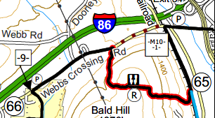 - April Miller
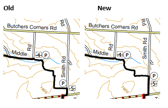 - April Miller
 - April Miller
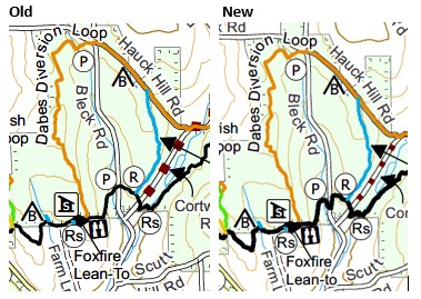 - Peter Dady RTC by April Miller FLTC Mapping
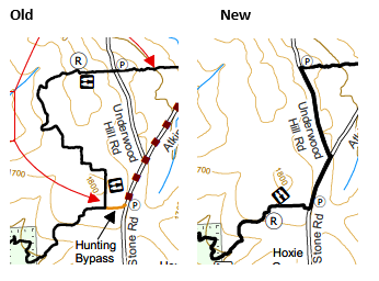 - April Miller
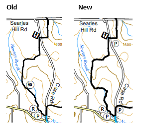 - April Miller
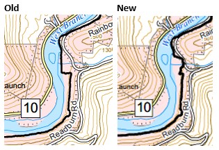 - RTC Rick Roberts by April Miller FLTC Mapping
 - Jo Taylor, FLTC Mapping
 - April Miller
 - April Miller
 - April Miller