
Hiking 101 #3
FLT Map M23 - Fred Stewart Road & Hoag Childes Road NY, United StatesFLT Map M23. Distance 3.5 miles.
$5
FLT Map M23. Distance 3.5 miles.
Thurs April 24th 10am: Logging operation clean up! Help clean up downed logs/branches, re-blazing. Sawyers certainly helpful, but not required. Meet at Map 8 Access 1: Fox Hill Rd. 42.5296, -77.9254 RSVP: Signup here
FLT Map L1. Distance 4 miles.
Register Hike Leader: Triple Cities Hiking Club hike leader Karen Harriell Hike Distance: ~7 miles FLT Map: International Loop #1 Hilly terrain, Moderate pace, approximately 7 miles in the western part of the James Kennedy State Forest along a combination of the Finger Lakes Trail and the International Trail’s Spanish Loop. The hike will follow a mix of […]
FLT Map L2 & M7. Distance 5 miles.
Hike Date: May 4, 2025, Sunday Start Time: 10 AM FLT Map: L1 Meet Location: Visitor’s Center of Mt. Morris Dam 6103 Visitor Center Rd, Mt. Morris, NY 14510 (GPS: 42.73132052997531, -77.90528823541558) Hike Leader: Genesee Valley Hiking Club hike leader Ann Bayley Hike Distance: 4 miles Description: Leisurely pace, 4 miles, mostly flat, spectacular views. Comfort station and picnic tables are […]
Thurs. May 8th, 10:30am: Sawyer work, Swift Hill SF. Rushford, NY Map 5. Meet at: 42.4583, -78.2496 RSVP: https://www.signupgenius.com/go/10C084FA4AB2BAAFBC70-56551544-swift
FLT Map L2. Distance ~2 miles.
Wed. May 14th, 10am: Benching and Blazing a new reroute trail. Map B2, Italy, NY Meet at Pulver Rd. 42.6325, -77.2483 RSVP: https://www.signupgenius.com/go/10C084FA4AB2BAAFBC70-56551569-italy
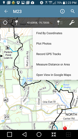
PDF map files available for download from the FLTC On-line Store are geospatial-enabled. This means that the files can be imported into mapping software available for many Apple and Android smart phones and tablets, and soon for Windows Phones.
We have tested our PDF maps with the Avenza PDF Maps Mobile App. Once you have installed this (free) app on your device, you can import the FLTC PDF map into the application.
Then, when you are hiking within the boundaries of the map, you can see your location acording to your device’s GPS. You can also do things like:
The free version of the Avenza app will only permit you to import three maps at one time. To import an additional map, you must first remove one of the three from the app. You can still keep the PDF files on your device and switch them at any time. There is a subscription version available from Avenza that will permit you to import an unlimited number of maps.
You can also purchase PDF versions of FLT maps from Avenza, and for purchased maps, there is no limit to the number you can import.
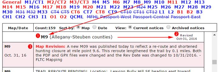
We revise paper maps, PDF files, and GPX files when trail conditions change significantly. When we do, we change the Revision Date of the map. We also apply minor updates to our maps as needed, and for these, we do not change the Revision Date. For all map changes, we post a Map Revision Notice on the Trail Condition Notices page on the website. You can use both the revision date and the Map Revision Notices to decide if you want to purchase a fresh copy of a map.
We do not change our maps for temporary conditions such as logging closures, storm damage, or special events, but we do post Trail Condition Notices.
We encourage hikers to always check the Trail Condition Notices page before hiking even if their maps are up to date. Here is a short tutorial:


We hope that this information will help you keep your maps and understanding of trail conditions up to date for the most satisfying and safe experience on the Finger Lakes Trail.
| The interactive maps may not display correctly in some browsers. For best results, use Firefox, Chrome, Edge, or Safari. If you are having trouble, try the segmented version of the map here. |
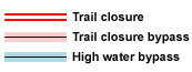 This is an overview map of the Finger Lakes Trail System. It shows tracks of the main trail, branch trails, loops and spurs. The track colors represent the blaze colors for the branch trails, loops, spurs, and sections of the main FLT not blazed in white. Most of the main FLT is depicted in black & white for better visibility on various map backgrounds, but blazed in white on the ground. Trail closures (hunting, logging, etc.) and recommended bypass routes are depicted as shown at right. Hover over a track to display the name and length. Tracks colored magenta and labeled “Non-FLT” show approximate location only and may not represent the condition and location of the trail on the ground.
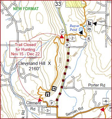
When you zoom in on a trail section, trailheads, notices, and important infrastructure such as lean-tos are also shown.
| Click the menu button in the upper right for commands to Change the map background and Adjust map opacity, | |
| Click the button in the upper right to view the map in the full window. Then click the geolocate button to show your present GPS location on the map. | |
| The following symbols appear on the map (use the Hide/Show Symbols menu in the upper right to control symbol visibility): | |
| Information about FLTC Maps, Also, connect to Trail Condition Notices directly from the |
|
| Trailhead with parking. Click the symbol for more information and for driving directions. | |
| Parking prohibited by law or landowner request. | |
| Parking Advisory – Limited or poor parking; some have nearby alternatives. | |
| Camping, including lean-tos, bivouac sites, public and private campgrounds. See Lean-tos, Bivouac Areas, and Campgrounds for more information | |
| Hunting closures. See Hunting Season Schedules for more information. | |
| Potable water | |
| Water source – TREAT BEFORE DRINKING | |
| FLT Passport hike is nearby. Click the icon to view details, obtain a map, or obtain the guidebook. | |
| Google street view. Drag the icon onto highlighted streets and click. (For more information) | |
| ½-mile tickmark – hover over a tickmark to display the mileage along the trail segment (Use Hide/Show Symbols menu to show the tickmarks). | |
| Connections to other long-distance hiking trails. | |
 |
Enter GPS coordinates (Latitude, Longitude) or an address (street address, town, or zip code) and click Find to recenter the map at that location. |
| Click on the center tool to show a small cross-hair in the center of the map. The tool shows the coordinates of the center if you pan or scroll the map. |
| The interactive maps may not display correctly with Internet Explorer. For best results, use Firefox, Chrome, Edge, or Safari. If you have a fast computer and fast network connection, you can try the unsegmented Full System version of the map here. |
 This is a overview map of the Finger Lakes Trail System. It shows tracks of the main trail, branch trails, loops and spurs. The track colors represent the blaze colors for the branch trails, loops, spurs, and sections of the main FLT not blazed in white. Most of the main FLT is depicted in black & white for better visibility on various map backgrounds, but blazed in white on the ground. Trail closures (hunting, logging, etc.) and recommended bypass routes are depicted as shown at right. Hover over a track to display the name and length. Tracks colored magenta and labeled “Non-FLT” show approximate location only and may not represent the condition and location of the trail on the ground.
When you zoom in on a trail section, trailheads, notices, and important infrastructure such as lean-tos are also shown.
| Click the menu button in the upper right for commands to Change the map background and Adjust map opacity, | |
| Click the button in the upper right to view the map in the full window. Then click the geolocate button to show your present GPS location on the map. | |
| The following symbols appear on the map (use the Hide/Show Symbols menu to control symbol visibility): | |
| Click for information about FLTC Maps, |
|
| Trailhead with parking. Click the symbol for more information. GPS coordinates, and for driving directions. | |
| |
Parking prohibited by law or landowner request. |
| Parking Advisory – Limited or poor parking; some have nearby alternatives. | |
| Camping: lean-tos, bivouacs, public and private campgrounds. See Lean-tos, Bivouacs, and Campgrounds for more information | |
| Hunting closures. See Hunting Season Schedules for more information. | |
| Potable water |
|
| ½-mile tickmark – hover over a tickmark to display the mileage along the trail segment (Use Hide/Show Symbols menu to show the tickmarks). | |
| Connections to other long-distance hiking trails. | |
 |
Enter GPS coordinates (Latitude, Longitude) or an address (street address, town, or zip code) and click Find to recenter the map at that location. |
| Click on the center tool to show a small cross-hair in the center of the map. The tool shows the latitude and longitude coordinates of the center if you pan or scroll the map. | |
| Select a map background from the list in the upper right. Use the menu icons to find tools to measure distance and control background opacity. |
Since our volunteer trail maintainers don’t visit the trail every day, we depend on you to notice and report trail conditions that need to be corrected. It could be a safety issue or just an inconvenience, but let us know about it. On the other hand, remember that the Finger Lakes Trail is a “primitive footpath” so that some conditions such as a steep rocky section, an occasional “step-over” log, or a section that is muddy in some seasons, are a natural part of the experience.
Please submit your trail condition reports by e-mail at [email protected]. If you do not have e-mail, call the FLT Service Center in Mount Morris at (585)658-9320. During times when the office is not open, please leave a voice message with a daytime phone number where we can reach you for more information.
Describe the problem clearly, being as specific as possible as to the location and nature of the problem. Include as much of the following as possible:
Give your best estimate of what is needed to correct the problem; we hate to send a crew with chainsaws only to find a small tree that could have been handled by one person with a handsaw.

FLTC volunteers attend 2-day training course in safe and efficient use of chainsaws for clearing blowdown
on the Finger Lakes Trail – Photo R. Hopkins
| The interactive maps may not display correctly with Internet Explorer. For best results, use Firefox, Chrome or Safari. |
This is an overview map of the portion of the North Country National Scenic Trail carried on the Finger Lakes Trail System. It shows only the main route of the NCNST; branches, loops, and spurs are not shown. The main FLT trail section is depicted in black for better visibility on various map backgrounds, but blazed in white on the ground. The Onondaga Trail section is depicted in blue and blazed in blue. Trail closures (hunting, logging, etc.) and recommended bypass routes are depicted as shown at right.
When you zoom in on a trail section, trailheads, notices, and important infrastructure such as lean-tos are also shown.
| Click the menu button in the upper right for commands to Change the map background and Adjust map opacity, | |
| Click the button in the upper right to view the map in the full window. Then click the geolocate button to show your present GPS location on the map. | |
| The following symbols appear on the map (use the Hide/Show Symbols menu to control symbol visibility): | |
| Click for information about FLTC Maps, |
|
| Trailhead with parking. Click the symbol for more information. GPS coordinates, and for driving directions. | |
| Parking prohibited by law or landowner request. | |
| Camping: lean-tos, bivouacs, public and private campgrounds. See Lean-tos, Bivouacs, and Campgrounds for more information | |
| Hunting closures. See Hunting Season Schedules for more information. | |
| Potable water |
|
| ½-mile tickmark – hover over a tickmark to display the mileage along the trail segment (use Hide/Show Symbols menu to show the tickmarks) | |
| Connections to other long-distance hiking trails. | |
|
Enter GPS coordinates (Latitude, Longitude) or an address (street address, town, or zip code) and click Find to recenter the map at that location. |
| Click on the center tool to show a small cross-hair in the center of the map. The tool shows the latitude and longitude coordinates of the center if you pan or scroll the map. | |
| Select a map background from the list in the upper right. Use the menu icons to find tools to measure distance and control background opacity. |
Current members of the Finger Lakes Trail are entitled to discounts on maps, stickers, and patches for sale on this website. A member coupon code is also provided for clothing and logo merchandise on the third-party website.
If your membership is current, you should see the ![]() symbol on discounted products. If you do not see this, please add this ($0.00) product to your EMPTY shopping cart. Then checkout. Log out of the website, log back in, and return to the store. You should now see the discount symbol and see discounted prices on your purchases.
symbol on discounted products. If you do not see this, please add this ($0.00) product to your EMPTY shopping cart. Then checkout. Log out of the website, log back in, and return to the store. You should now see the discount symbol and see discounted prices on your purchases.
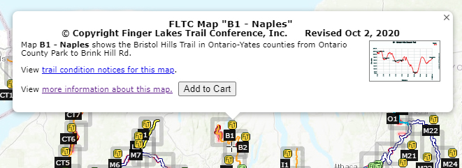
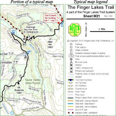
Download a sample paper map in PDF form here.
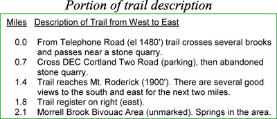
The following are examples from a typical map:
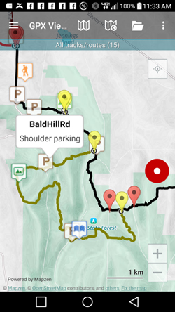
The FLTC offers downloadable files containing complete track and complete waypoint GPS data detailing all of the approximately 1,000 miles of the FLT, including main, loop, branch, and spur trails. In addition to GPS data, the downloadable files contain PDF images of the paper maps. GPS data is in the form of GPX files that can be loaded onto smart phones supporting GPX apps.
The free GPX Viewer from Vectura will enable you to view our maps on your Android phone. Tracks and waypoints are displayed on a variety of on-line map backgrounds along with your present location.
GPX Viewer Pro (license fee) has all of the features of GPX Viewer plus you can record the track of your hike. You can also download background maps to your device that can be viewed during your hike even if you have no cell phone coverage.
If you have experience using other smart phone apps, please let us know at [email protected].


