10 events found.


Founder’s Hike – Howard Beye
FLT Map M19 - Daisy Hollow Rd North TrailheadRegister Hike Leader: Triple Cities Hiking Club hike leader Karen Harriell Hike Distance: ~7 miles FLT Map: International Loop #1 Hilly terrain, Moderate pace, approximately 7 miles in the western part of the […]
Free

Hiking 101 #5
FLT Map M07 - Whiskey Bridge on River Road 42.5586, -78.0479FLT Map L2 & M7. Distance 5 miles.
$5
Founder’s Hike – Wally Wood
FLT Map L1 - Visitor’s Center of Mt. Morris Dam 6103 Visitor Center Rd, Mt Morris, NY, United StatesHike Date: May 4, 2025, Sunday Start Time: 10 AM FLT Map: L1 Meet Location: Visitor’s Center of Mt. Morris Dam 6103 Visitor Center Rd, Mt. Morris, NY 14510 (GPS: 42.73132052997531, -77.90528823541558) Hike Leader: Genesee […]
Free
Trail Work – Map 5
FLT Map 05 - Swift Hill State Forest Parking AreaThurs. May 8th, 10:30am: Sawyer work, Swift Hill SF. Rushford, NY Map 5. Meet at: 42.4583, -78.2496 RSVP: https://www.signupgenius.com/go/10C084FA4AB2BAAFBC70-56551544-swift

Yoga Hike #1
FLT Map L2 - Parade Grounds 9280 Parade Grounds Rd, Hunt, New YorkFLT Map L2. Distance ~2 miles.
$25
Trail Work – Map B2
FLT Map B2 - Pulver RdWed. May 14th, 10am: Benching and Blazing a new reroute trail. Map B2, Italy, NY Meet at Pulver Rd. 42.6325, -77.2483 RSVP: https://www.signupgenius.com/go/10C084FA4AB2BAAFBC70-56551569-italy
Free
Single Hike: Allegany County Hike Series May 17
Allegany County, NY (entire county)Register by May 14 Guided point-to-point group hike with the County Hike Series program includes bus transportation and support. This hike joins one of the six County Hike Series outings. […]
$35
Hiking 101 #6
FLT Map B3 - Bean Station Rd Bean Station RdFLT Map B3 & HBL. Distance 3 miles. Dogs are NOT allowed on this hike.
$5
Trail Work – Map 4
FLT Map 04 - Boyce Hill State ForestWed. May 21st, 11am: Clearing trail at Boyce Hill SF. Franklinville, NY Map 4. Meet at:42.3378, -78.5549 RSVP: https://www.signupgenius.com/go/10C084FA4AB2BAAFBC70-56551607-boyce
Free

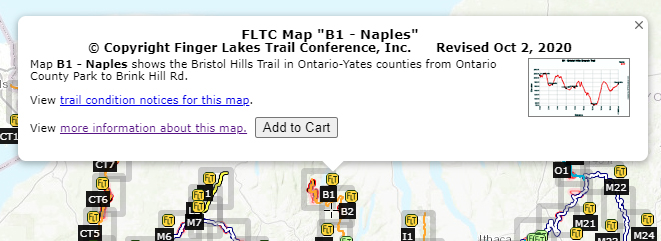

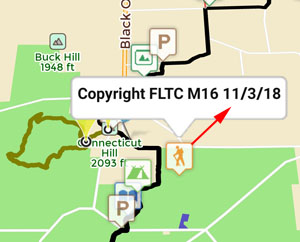
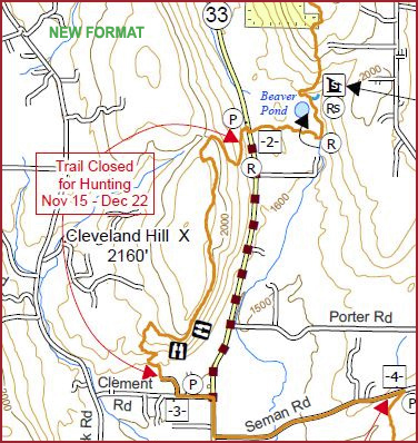
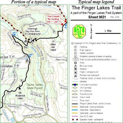
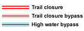 This is an overview map of the Finger Lakes Trail System. It shows tracks of the main trail, branch trails, loops and spurs. The track colors represent the blaze colors for the branch trails, loops, spurs, and sections of the main FLT not blazed in white. Most of the main FLT is depicted in black & white for better visibility on various map backgrounds, but blazed in white on the ground. Trail closures (hunting, logging, etc.) and recommended bypass routes are depicted as shown at right. Hover over a track to display the name and length. Tracks colored
 This is a overview map of the Finger Lakes Trail System. It shows tracks of the main trail, branch trails, loops and spurs. The track colors represent the blaze colors for the branch trails, loops, spurs, and sections of the main FLT not blazed in white. Most of the main FLT is depicted in black & white for better visibility on various map backgrounds, but blazed in white on the ground. Trail closures (hunting, logging, etc.) and recommended bypass routes are depicted as shown at right. Hover over a track to display the name and length. Tracks colored