Huckleberry Bog Nature Trail, Loop, and Shelter
By Irene Szabo
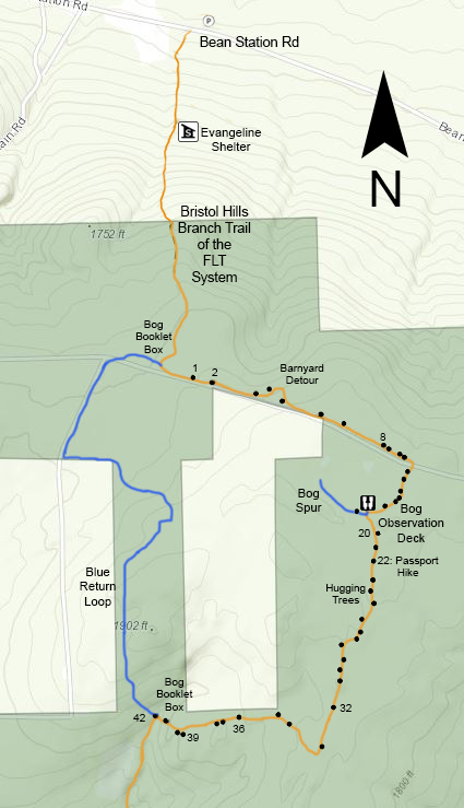
On Map B3, just south of Bean Station Road, the Bristol Hills Branch Trail goes uphill through private land to Urbana State Forest, where there is a 3 mile loop trail, both orange and blue-blazed, part of which is now a nature trail intended for use with the booklets in boxes at each end of the loop.
History
Back around 1990 the Bristol Hills Branch Trail followed some of what is now the blue part of the loop trail, rather slavishly following the border with private land simply because some under-imaginative Scout leaders laid it out. At the same time, the DEC foresters in their Unit Management Plan (one of the first in the State) suggested that the Finger Lakes Trail Conference should build a trail over to the huckleberry bog. I was just in the process of taking over that dull Boy Scout segment, so explored to find this rumored bog. Well, once I saw the oak woods and bog, I agreed with the State, and even obtained their permission to make it a loop trail, which hadn’t been in their original idea.
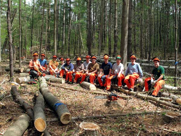
Subsequently over the years I moved the blue off the border in several places to visit nice spots, got the observation deck (another DEC idea in the Unit Management Plan) on the edge of the bog built with EMS funding and volunteers for a National Trails Day (and week, ha) project. While Steph Spittal, Bob Muller, and I were still building the orange part of the loop in 1991, we became enthused by all the plant variety along the way and tried to figure out how to make a nature trail out of it. Eventually we settled on the painted metal number tags (after local fauna ate all the plywood signs we first tried; they love to gnaw that glue) with a booklet that had to be carried around the loop, keyed to the numbers. Steph even paid the Letchworth State Park naturalist to come with us one day to identify all the plants, a way faster solution to identifying them than dragging along all the books.
The early booklet was a crude affair, made before I had ever touched a computer. Typed text blocks and line drawings taped on white paper were run off on a copier, period. Then a wonderful energetic imaginative science teacher at Wayland-Cohocton High School, Rob Hughes, invented a project for his honors students. They took my text and made it into the current style of comb-bound laminated booklet, which they run off at the local BOCES for us, with the school system’s blessing. Very cool. Notice in the register how many people enjoy that loop trail, including a surprising number of international visitors!
The Evangeline Shelter
From Bean Station Road uphill to the spot where a crudely lettered sign warns against incursions by anybody except hikers and skiers is indeed private land, owned in the early 1990’s by Bill and Ellen Garrison. The trail used to head south from the road one property to the east and then meander onto the Garrisons’ place further uphill, but Bill invited us to put the trail on his place, which would give us a chance to walk by the cemetery that he and some geezer buddies were restoring from terrible neglect.
In the early 90’s when the FLTC announced through our newsletter that we were instituting the concept of permanent trail easements, Bill OFFERED to give us one, the first and only instance of that much voluntary generosity. All other easements since then have been asked for first. So our route is protected from both sides of Bean Station Road all the way up to the State Forest border at the hand-painted sign, even though the Garrisons moved away before 2010.
The Evangeline shelter was Bill’s idea, too. (Side note: before a stroke frustrated his brain, he was the kind of character who could quote literal pages of such drivel as Evangeline) He got logs from the state forest, with permission of course, and we provided a crew of volunteers and Americorps kids to put it up. Bill got a local teacher with masonry skills to build the fireplace. It was immediately popular with hikers, any of whom may stay there at any time, first come.
Then a rather twisted child from the neighborhood spent time there one night with other kids, and they managed to burn the place to the ground. Bill utilized his homeowner’s insurance to get enough money for a replacement shelter by the following summer, bigger and better than ever, and only part of it was done by volunteers this time. It’s that rare occurrence, a private shelter on private land, but with no restrictions on its use (except for one ex-child who is forbidden by the sheriff from appearing there ever again). Evangeline continues to be heavily used, but with no more unfavorable situations.
The Bog
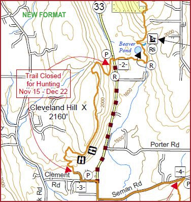
Study the loop map painted onto the “lid” of the box at either end, which demonstrates some of the novelty of this hilltop bog apparently created by a blob of leftover glacial ice.
It’s a special place for sure, and we remain grateful that the DEC nudged us into building trail here. To the best of my knowledge, this is the only time that they have suggested we build new trail to an interesting place.


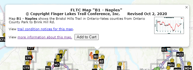

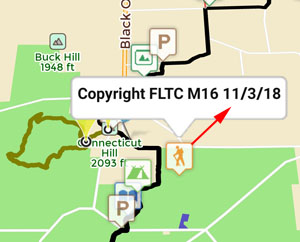
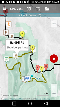
 This is an overview map of the Finger Lakes Trail System. It shows tracks of the main trail, branch trails, loops and spurs. The track colors represent the blaze colors for the branch trails, loops, spurs, and sections of the main FLT not blazed in white. Most of the main FLT is depicted in black & white for better visibility on various map backgrounds, but blazed in white on the ground. Trail closures (hunting, logging, etc.) and recommended bypass routes are depicted as shown at right. Hover over a track to display the name and length. Tracks colored
 This is a overview map of the Finger Lakes Trail System. It shows tracks of the main trail, branch trails, loops and spurs. The track colors represent the blaze colors for the branch trails, loops, spurs, and sections of the main FLT not blazed in white. Most of the main FLT is depicted in black & white for better visibility on various map backgrounds, but blazed in white on the ground. Trail closures (hunting, logging, etc.) and recommended bypass routes are depicted as shown at right. Hover over a track to display the name and length. Tracks colored