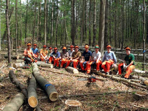
• Facebook
  • Instagram
  • Youtube
  • Donate
  • My Account
  • Checkout
  • Cart
  • 0Shopping Cart
Finger Lakes Trail Conference
  • Home
  • What’s Happening
    • Calendar
    • Special Events
      • Fall Weekend
      • FLTC Backpacking Treks
      • Naples Trails Day
      • Yoga Hikes
      • Women’s Weekend Retreat
      • FLT Connect
    • Hiking Programs
      • Cross-County Hike Series
      • Founder Hikes
      • Hiking 101
      • FLT50/100
      • Passport Hikes
    • Social Media, Newsletter and Discussion Group
  • Go Hiking
    • Trail Conditions
    • FLT Interactive Trail Maps
      • FLT Full System Map
      • Allegany Region Map
      • Western Finger Lakes Region Map
      • Eastern Finger Lakes Region Map
      • Catskill Region Map
      • North Country Trail on Finger Lakes Trail in NY
    • Passport Booklets
    • About the Finger Lakes Trail
    • Hiking the FLT – Basics
    • End-to-End Hiking
    • Special Places
    • Beyond the Hike
    • Parks
  • Shop the Store
    • Maps and GPS
    • Map Sets
    • Individual Maps: Index Map Picker
    • Individual Maps: Product Pages
    • Passport Booklets
    • Become A Member
    • Make a Donation
    • Stickers and Patches
    • FLT Gear
  • About the FLTC
    • What is FLTC
    • Service Center
    • Employment
    • Organization
    • Meet the Board of Managers
    • FLT Ambassador Program
    • Volunteer
    • Support the FLTC
    • Awards
    • History of the FLTC
    • Affiliate Hiking Clubs
    • Links
    • Contact Us
  • Members
    • Join/Renew
    • Make a Gift
    • In Your Words
    • Business Members
    • Business Sponsors
    • Volunteer
    • FLTC Library
  • Search
  • Menu

Archive for category: Fall Weekend

You are here: Home / Hiking Programs / Fall Weekend

Fall Weekend Hikes

July 19, 2023/in Fall Weekend /by Finger Lakes
Friday Hikes

Hike List

  • F1 - Stony Brook State Park
  • F2 - Robinson Loops
  • F3 - Dalton to Swain
  • F4 - Wallace D Wood Memorial

F1 - Stony Brook State Park

Meeting PointSwain Resort
Meeting Time12:30 PM
Hike StartsStony Brook State Park
Map
Mileage~2.5 miles
DifficultyModerate
Hike LeaderTBA
DescriptionEnjoy the beautiful gorge and waterfalls at this lovely state park. The hike will begin in the main parking lot. The trail will form a loop of the East Rim Trail and the Gorge Trail for a total mileage of around 2.5 miles, with roughly 500 feet of elevation gain.

F2 - Robinson Loops

Meeting PointSwain Resort
Meeting Time12:45 PM
Hike StartsSwain Resort
MapM8Buy Map
Mileage3-4 miles
DifficultyEasy to Moderate
Hike LeaderTBA
Description Leave from the resort parking lot and enjoy a flat stroll past the ski slopes. Enter the woods on an old rail bed and meet up with the junction of the Robinson Loop trails. Wander around on these loops before heading back to the resort on the old rail bed.

F3 - Dalton to Swain

Meeting PointSwain Resort
Meeting Time1:00 PM
Hike StartsFox Hill Rd.
MapM8Buy Map
Mileage3.7 miles
DifficultyModerate to Hard
Hike LeaderMare Steiniger
DescriptionAn interesting hike along the hills of Dalton and Swain. A variety of landscapes: fields and forest. Some conversation pieces along the trail and perhaps some mysterious creatures. Covering just under 4 miles, this section has some steep gullies and roller coaster hills before you reach an old logging road and barn. End at Kennedy Rd where you will spot some cars. This covers part of County Hike Series #6

F4 - Wallace D Wood Memorial

Meeting PointSwain Resort
Meeting Time1:30 PM
Hike StartsBailey Rd.
MapM7Buy Map
Mileage~4 miles
DifficultyModerate
Hike LeaderTBA
DescriptionThis will be a short/steep hike with a history lesson! Cars will park on Bailey Rd. by Whiskey Bridge. Follow the trail south along road/dirt lane, heading uphill. Reach trail register and views of the Genesee River. Descend to South River Rd. then a short uphill to the private Hesse Lean-to and Wallace D Wood Memorial. Learn about the history of the FLT and the man who birth the idea of our trail across New York State! Backtrack to the cars at Bailey Rd.
Saturday Hikes

Hike List

  • Sa1 - Letchworth State Park
  • Sa2 - Swain to Slader Creek Rd
  • Sa3 - Rattlesnake Hill, new lean-to
  • Sa4 - Genesee Valley Greenway-Oakland Locks

Sa1 - Letchworth State Park

Meeting PointSwain Resort
Meeting Time8:45 AM
Hike StartsOctagon Parking lot
MapL2Buy Map
Mileage7 miles
DifficultyModerate
Hike LeaderChris DeGolyer
DescriptionThe hike starts in the Octagon Parking lot near Lower Falls. Follow Trail #1 west along the gorge to Inspiration Point. Just past Inspiration Point at the Civil War Monument, cross the park road to the trout pond and follow part of Trail #3 to Trail #2A to Trail #2 back to Trail #1 along the gorge northeast to the starting point. Bring a lunch!

Sa2 - Swain to Slader Creek Rd

Meeting PointSwain Resort
Meeting Time9:00 AM
Hike StartsSwain Resort
MapM8Buy Map
Mileage5 miles
DifficultyModerate
Hike LeaderTBA
DescriptionSpot cars at Slader Creek Rd. Access 7. Start at the Swain Resort parking lot and head south on the FLT main trail. The trail stays level for a couple miles as you follow the old rail bed through the woods. Then head up through a beautiful section of forest and pastures to Bossard’s cabin. Visit with friendly cows and enjoy the view of the next hill, then head down to the cars spotted at Slader Creek Rd. You’ll climb over a few stiles along this hike. This hike covers half of County Hike Series # 2.

Sa3 - Rattlesnake Hill, new lean-to

Meeting PointSwain Resort
Meeting Time9:15 AM
Hike StartsAccess 3, NY70
MapM8Buy Map
Mileage4 miles
DifficultyModerate to Hard
Hike LeaderTBA
DescriptionLeave some cars at Swain Resort parking lot. The hike will start just a short drive up NY70. At access 3, the hike will begin a steep ascent within Rattlesnake Hill WMA. Switchbacks will help ease the terrain. Once you reach the summit, enjoy the pond and forest. Reach the newly built lean-to just off the main trail. Then descend along English Hill Rd. into the town of Swain where you will end the hike.

Sa4 - Genesee Valley Greenway-Oakland Locks

Meeting PointSwain Resort
Meeting Time9:30 AM
Hike StartsOakland Locks parking area
MapGVGSP
Mileage2 miles
DifficultyEasy
Hike LeaderTBA
DescriptionWalk between mile point 53 and 54 of the Genesee Valley Greenway. Learn about the canal and see the remnants of the locks here. Flat trail, out and back.
Sunday Hikes

Hike List

  • Su1 - Stickles Rd.
  • Su2 - Town and Greenway

Su1 - Stickles Rd.

Meeting PointStickles Road, off County Route 3, Centerville-Hume Rd. (GPS: 42.471, -78.1974)
Meeting Time11:00 AM
Hike StartsStickles Road, off County Route 3, Centerville-Hume Rd. (GPS: 42.471, -78.1974)
MapM6Buy Map
Mileage3.5 miles
DifficultyEasy to Moderate
Hike LeaderBob Schooley
DescriptionThe hike will be in a private forest, along the FLT. It’s a beautiful hike to a huge, old Black Cherry tree. We’ll stop for a snack break at a simple camp before hiking back to the cars. It is a mostly level hike with slight elevation.

Su2 - Town and Greenway

Meeting PointMount Morris Veterans Memorial Park
Meeting Time9:00 AM
Hike StartsSonyea State Forest southern trailhead
MapGVGSP
Mileage5 miles
DifficultyEasy to Moderate
Hike LeaderMare Steiniger
DescriptionDrive a couple cars to the start of Sonyea State Forest. Begin hiking north through the forest, taking in the scenery. Follow forest roads, enter the correctional facility premises before paralleling county roads on the Greenway. Enter Mount Morris and hop off the Greenway to enjoy some ice cream/lunch/shopping before making your way back to the cars at the Veterans Memorial park.
Explore On Your Own

Bath National Cemetery

  • Location: VA Medical Center, San Juan Avenue
  • Bath, NY 14810
  • Grounds open sunrise to sunset
  • https://www.cem.va.gov/CEM/cems/nchp/bath.asp

Glenn H. Curtiss Museum

  • Transportation museum with a large aviation collection
  • Location: 8419 NY-54, Hammondsport, NY 14840
  • Open 9am-5pm
  • https://glennhcurtissmuseum.org/

New York State Fish Hatchery

  • Open to the public for visiting
  • Location: 7169 Fish Hatchery Rd, Bath, NY 14810

Corning Museum of Glass

  • Location: 1 Museum Way, Corning, NY 14830
  • Open 9am-7pm
  • https://home.cmog.org/

Keuka Lake State Park

  • Boat launch, Hiking
  • Location: 3560 Pepper Rd, Keuka Park, NY 14478
  • https://parks.ny.gov/parks/keukalake/maps.aspx

Finger Lakes Boating Museum

  • Location: 8231 Pleasant Valley Rd, Hammondsport, NY 14840
  • Open 10am-5pm
  • https://www.flbm.org/

Templar Falls

  • Location: Templar Falls, 2801-2821 Locust Ln, Watkins Glen, NY 14891
  • About 30 min drive from venue

Finger Lakes Land Trust Preserves

  • Hike in beautiful Natural Areas and Preserves managed by the Finger Lakes Land Trust in Tompkins County and surrounding Counties. 
  • See GoFingerLakes.org for an interactive map of over 50 hiking, biking, paddling, skiing, and outdoor adventure destinations across the region!

Windmill Farm and Craft Market

  • Location: 3900 NY-14A, Penn Yan, NY 14527
  • https://www.thewindmill.com/

Stony Brook State Park

  • Hiking, Swimming, Waterfalls
  • Location: 10820 Route 36 South, Dansville, NY 14437
  • https://parks.ny.gov/parks/stonybrook/details.aspx

Watkins Glen State Park

  • Hiking, Swimming, Waterfalls
  • Location: 1009 N Franklin St, Watkins Glen, NY 14891
  • https://parks.ny.gov/parks/watkinsglen/maps.aspx

Village of Watkins Glen, NY
Village of Hammondsport, NY

Breweries, Distilleries, Wineries (Please check opening hours)

  • Pleasant Valley Wine
  • Chateau Renaissance Wine Cellars 
  • Tub Town Brewing 
  • Steuben Brewing Co.
  • Finger Lakes Beer Company
  • The Brewery of Broken Dreams
  • Keuka Brewing Co.
  • Burgers & Beer of Hammondsport
  • Over the Bridge Wine
  • Climbing Bines Hop Farm & Brewery
  • Barrelhouse 6 Distillery
  • Krooked Tusker Distillery 
  • Canada Wine Co.
  • Heron Hill Winery
  • Bully Hill Vineyards 
  • Keuka Lake Vineyards 
  • Living Roots Finger Lakes
https://fingerlakestrail.org/wp-content/uploads/2017/02/finger-lakes-trail-logo-small.png 0 0 Finger Lakes https://fingerlakestrail.org/wp-content/uploads/2017/02/finger-lakes-trail-logo-small.png Finger Lakes2023-07-19 21:15:462025-02-08 11:26:10Fall Weekend Hikes

Fall Weekend Registration Form

May 29, 2023/in Fall Weekend /by Finger Lakes


Looking for more information about Fall Weekend, including the Schedule of Events and Lodging options?  Check out the Fall Weekend Information Page.

The online registration form only support payments via credit cards, Apple Pay, Google Pay, and PayPal.
If you wish to register using another form of payment please call the main office at 585-658-9320.

Fall Weekend Registration

1Begin
2Hiker Information
3Photo Waiver
4Hike Options
5Emergency Contact
6Liability Waiver
7Meal Options
8Donation
9Complete
This field is hidden when viewing the form
You are currently logged in as . If you need to switch to another account you can Logout.

If you are already a member, you can log into your account to auto-fill many of the form fields with your information. If you are not yet a member, you can sign up right through the registration form and receive a discount immediately.

This field is hidden when viewing the form
Fall Weekend Hike Leader
You currently have an active membership. If you purchase a membership through the registration form it will renew your current membership and extend it for a period of one year beyond the current expiration date (Individual and Family Memberships only).

Hiker Information

Note for Family Membership holders: Currently the website is only able to associate a membership to one account/email address. If you have a Family Membership and wish to add an additional adult registration be sure you are logged in as the account holder. Change the information below to match that of the additional adult hiker.
2025 County Hike Participant(Required)
As a county hiker you are eligible for a limited free registration. To receive the registration fee waiver you may only sign up for the Saturday Dinner ($25) and/or the Awards Ceremony. Selection of any other option - hikes or meals - will void the registration fee waiver.
Name(Required)
Address(Required)
Email(Required)
This field is hidden when viewing the form
Birth Date
Photo Release Consent(Required)
I hereby grant the Finger Lakes Trail Conference (FLTC) permission to use my name and/or likeness taken in any photograph or digital media in any of its promotions, publications, press releases, brochures, website or social media entries without payment or any other consideration.

I understand and agree that any photograph or digital images are the property of the FLTC and hereby irrevocably authorize the FLTC to edit, publish, or distribute these for purposes of promoting or publicizing the Finger Lakes Trail. I waive the right to inspect or approve the finished product, wherein my likeness appears. Additionally, I waive any right to royalties or other compensation arising or related to use of these images.

I hereby hold harmless and release and forever discharge the FLTC from all claims, demands, and causes of action, which I, my heirs, representatives, executors, administrators, or any other persons acting on my behalf or on behalf of my estate have, or may have by reason of this authorization.

I am 18 years of age or older and am competent to contract in my own name. I have read this release before indicating agreement at checkout and I fully understand the contents, meaning, and impact of this release.

Hike Options

See Fall Weekend Hikes for a complete listing of all available hikes, including start time, distance, and difficulty.
Annual Membership Meeting (4pm Saturday)(Required)
Awards Ceremony (after dinner Saturday)(Required)

Emergency Contact Information

Please note, your emergency contact cannot be someone who is also hiking.

Emergency Contact Name(Required)
Email(Required)
Liability Waiver Consent(Required)
Those persons enjoying the Finger Lakes Trail (FLT) and/or activities sponsored by the Finger Lakes Trail Conference (FLTC) or any clubs conducting activities on behalf of, or in support of the FLTC, accept full, personal responsibility for their own well-being, or, for the well-being of a minor when acting in the capacity of parent or guardian. Furthermore, users of the Finger Lakes Trail accept and understand that hiking is a rigorous activity often conducted in rugged, outdoor conditions subject to variations in weather and terrain that may involve the risk of injury or death, and that they are fully responsible for their own safety and for selecting activities consistent with their physical capabilities.

I am 18 years of age or older and am competent to contract in my own name. I have read this release before indicating agreement at checkout and I fully understand the contents, meaning, and impact of this release.

Meal Options

Lunch: Choice of ham or turkey wrap with lettuce, tomato and onion or a vegetarian wrap (spinach wrap) with hummus, zucchini, squash, roasted red pepper, and white onions. All lunches include a piece of fruit, a bottle of water and a cookie.

Friday Dinner

Friday Meals
Dinner includes BBQ chicken or veggie fried ravioli, seasonal vegetables, salt potatoes, and garden salad. Drinks: water, lemonade, iced tea, coffee, and tea. Dessert: cookies and brownies

Saturday Meals

Saturday Meals
Dinner includes roasted pork loin, turkey, or stuffed mushroom (veg); mac & cheese, green beans and garden salad. Dessert: cookies, brownies, and cake.
Choice of ham or turkey wrap with lettuce, tomato and onion or a vegetarian wrap (spinach wrap) with hummus, zucchini, squash, roasted red pepper, and white onions. All lunches include: chips, a piece of fruit, a bottle of water, and a cookie.

Sunday Meals

Sunday Meals
Choice of ham or turkey wrap with lettuce, tomato and onion or a vegetarian wrap (spinach wrap) with hummus, zucchini, squash, roasted red pepper, and white onions. All lunches include: chips, a piece of fruit, a bottle of water, and a cookie.
This field is hidden when viewing the form
Please indicate any dietary restrictions (e.g. vegetarian, vegan, gluten free, etc.), food allergies, and/or special needs and concerns.

Donation

The Finger Lakes Trail Conference is grateful for the many generous members and donors who make financial contributions. Your donations provide critical funding to support all the work we do to protect, maintain, and enhance the Finger Lakes Trail System throughout the year. Your gift will help fund trail maintenance and preservation, and support our trail community in countless ways.

Please make your gift today!

Receipt Table

This field is hidden when viewing the form
Payment Method(Required)

https://fingerlakestrail.org/wp-content/uploads/2017/02/finger-lakes-trail-logo-small.png 0 0 Finger Lakes https://fingerlakestrail.org/wp-content/uploads/2017/02/finger-lakes-trail-logo-small.png Finger Lakes2023-05-29 10:27:232025-07-11 13:02:39Fall Weekend Registration Form

Fall Weekend

July 26, 2021/in Fall Weekend /by Christy Post

Swain, NY | September 19 – 21, 2025

Join us for a weekend of all things hiking from September 19th to 21st at Swain Resort in Swain, NY!

Registration

Fall Weekend Celebration isn’t just about hiking the FLT. Whether you’re new to hiking, unfamiliar with the FLTC, or a seasoned pro, Fall Weekend is a time for making new friends, catching up with old friends, and spending time with like-minded people who love the great outdoors.


🎉 What to Expect

✔️ Explore scenic trails with guided hikes
✔️ Celebrate the end of the County Hike Series

✔️ Enjoy social hours, bonfires, and trail talks
✔️ Experience our Annual Awards Presentation
✔️ Attend the FLTC Annual Meeting (Not a member? Join Now!)

Schedule of Events


All Fall Weekend Festival activities will be held at Swain Resort in Swain, NY


Friday, September 19

  • 12:00 PM: Check-in
  • 12:45–5:00 PM: Short afternoon hikes
  • 5:00 PM: Happy Hour – “Find-a-Person” Bingo
  • 6:00 PM: Dinner
  • 7:00 PM: Lightning Presentations (Trail Projects, Nature, Adventure)
  • 8:15 PM: Bonfire & S’mores

Saturday, September 20

  • 8 AM – 5 PM: Fall Weekend Sign-In
  • 8 AM – 8:30 AM: Lunch Pick Up (must be pre-ordered with registration)
  • 9:00 AM–2:00 PM: Guided hikes
  • 2:00 PM: County Hike Series Celebration
  • 4:00 PM: Annual Membership Meeting
  • 5:00 PM: Happy Hour
  • 6:00 PM: Dinner
  • 7:00 PM: Awards Ceremony
  • 8:00 PM: Bonfire & S’mores

Sunday, September 21

  • 8:00 AM: Coffee & Sidote Fund Update
  • 8:00 – 8:30 AM: Lunch Pick Up (must be pre-ordered with registration)
  • 8:30 AM–2:00 PM: Guided hikes
  • 10:00 AM: FLTC Board Meeting

Lodging


Lodging accommodations are directly through Swain Resort. Attendees have options to reserve a tent site (primitive for our event only!), a cabin, or a cottage/lodge.

Tent Camping Reservations: Guests who would like to tent camp can reserve a spot by calling 607-545-6511 and speaking directly with Breanna. Tent camping is $10 per person, per night. This is primitive camping.

Address: 2275 Co Rd 24, Swain, NY 14884
Phone: (607) 545-6511
Website: https://www.swain.com

Registration
https://fingerlakestrail.org/wp-content/uploads/2017/02/finger-lakes-trail-logo-small.png 0 0 Christy Post https://fingerlakestrail.org/wp-content/uploads/2017/02/finger-lakes-trail-logo-small.png Christy Post2021-07-26 16:19:432025-07-11 13:05:07Fall Weekend


FLT Service Center

Finger Lakes Trail Conference, Inc.

Contact Us | Privacy Policy

© Copyright 2025 The Finger Lakes Trail Conference
  • Facebook
  • Instagram
  • Youtube
Geospatial PDF maps

PDF map files available for download from the FLTC On-line Store are geospatial-enabled. This means that the files can be imported into mapping software available for many Apple and Android smart phones and tablets, and soon for Windows Phones.

We have tested our PDF maps with the Avenza PDF Maps Mobile App. Once you have installed this (free) app on your device, you can import the FLTC PDF map into the application.

Then, when you are hiking within the boundaries of the map, you can see your location acording to your device’s GPS. You can also do things like:

  • Add placemarks
  • Record your own track
  • Tag photos
  • Orient the map using your compass
  • Measure distance and area
  • Search for places on the map

The free version of the Avenza app will only permit you to import three maps at one time. To import an additional map, you must first remove one of the three from the app. You can still keep the PDF files on your device and switch them at any time. There is a subscription version available from Avenza that will permit you to import an unlimited number of maps.

You can also purchase PDF versions of FLT maps from Avenza, and for purchased maps, there is no limit to the number you can import.

How to use this page

Consult with this page for notices of trail conditions before you leave for your hike. Click on the “Sort by” option to sort the notices by map name or by date. Don’t know your map name? Go to the index map look for the name (M09 or M9 for example) nearest your hike location.

When sorted by map name, the notices are listed going from west to east on the main trail, and then north to south on the branch trails (south to north on Conservation and Onondaga trails). Click on the map names above the table to jump to the notices for a particular map. You can then scroll up and down to view other nearby notices.

  • Map names in red indicate that one or more notices for that map contain hunting notices or other temporary trail closures. Check carefully for these notices during hunting season(s) in your area.
  • Map names underlined in gray have no notices.

The date of the most recent major revision is shown for each map. Check the revision date on your map to see if it might be outdated. All changes to maps—both major revisions and minor updates—are reported as Trail Notices highlighted in pink. Use these notices to decide when you want to replace an outdated map.

When sorted by Date the notices are listed with the most recent notices anywhere on the FLTC system listed first.

Some older notices have been archived as they may contain information that is still useful if you have not visited the trail recently. Click the “Archived” link to view these notices.

More about trail conditions

Trail conditions change frequently. You can help by reporting problems you see. But please read How to Report Trail Conditions before submitting your report.

Trail Conditions are posted when reported and verified. Conditions are rectified if and when volunteers are available.

The FLT is a “primitive footpath.” If you are looking for a smooth, easy “walk in the park” then you might prefer a park for your walking. On the other hand, if you are looking to challenge yourself and get away from “engineered” experiences, then come to the Finger Lakes Trail.

Nevertheless, we want the condition of the Finger Lakes Trail to be the best it can be. Every section of the trail is maintained by stewards and trail adopters who are members of the FLTC and affiliate clubs and organizations. These people volunteer their time because they care about the Finger Lakes Trail. They also care about your experience on the trail. They visit their section of trail several times each year to look for problems: trail erosion, litter, vegetation infringement on the trail, fallen trees and branches, blazes and signs that need to be replaced or refreshed, and infrastructure that needs repair. In short, they look for things that will interfere with your wilderness hiking experience.

Trail volunteers also interact with our private landowners who have agreed to share a portion of their property with FLT hikers. Our volunteers are the first to know when land ownership may change, or when the landowner has had a problem on their section of trail.

Whether you are a new or experienced hiker, if you find a problem on the trail, let us know! Visit the Trail Condition Reporting page for more information.

Remember, some sections of the trail are closed during hunting seasons which include Spring and Fall turkey seasons, and Fall big game seasons. Closures are listed in red in the Trail Condition Notices. Dates are listed on Hunting Season Schedules.

And, when you are ready, join us as a volunteer to help keep the Finger Lakes Trail one of the best hiking trails in the world.

Are my paper maps, PDF files, and GPX files up to date?

We revise paper maps, PDF files, and GPX files when trail conditions change significantly. When we do, we change the Revision Date of the map. We also apply minor updates to our maps as needed, and for these, we do not change the Revision Date. For all map changes, we post a Map Revision Notice on the Trail Condition Notices page on the website. You can use both the revision date and the Map Revision Notices to decide if you want to purchase a fresh copy of a map.

We do not change our maps for temporary conditions such as logging closures, storm damage, or special events, but we do post Trail Condition Notices.

We encourage hikers to always check the Trail Condition Notices page before hiking even if their maps are up to date. Here is a short tutorial:

  1. On the Interactive Map hover over the FLT icons ( flticon.gif or flticonLoop.gif ) to display the revision date. Click on the icon ❶ to see more information about the map. Click on the link ❷ to display the trail condition notices for the map.
    Uptodate1.jpg
  2. On the Trail Condition Notices with the sorting option set to “Map,” click on the map name to jump to the trail notices ❶ for that map. Then look in the heading for the map for a description of the map and the latest revision date ❷. Also, check for Map Revision Notices ❸ shaded in pink.
    Uptodate2.jpg
  3. In the On-line map store hover over or click a map icon flticon.gif  on the Purchase Individual Maps page.
  4. With a PDF or Paper map, the revision date is shown in the Title box.
  5. When viewing a GPX file on a GPS device or GPX Viewer app on a smart phone, the revision date is included in the copyright waypoint symbol.

We hope that this information will help you keep your maps and understanding of trail conditions up to date for the most satisfying and safe experience on the Finger Lakes Trail.

How to use this map

The interactive maps may not display correctly in some browsers. For best results, use Firefox, Chrome, Edge, or Safari. If you are having trouble, try the segmented version of the map here.

Map_Legend.jpg
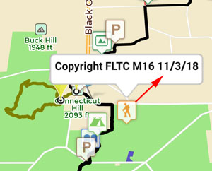
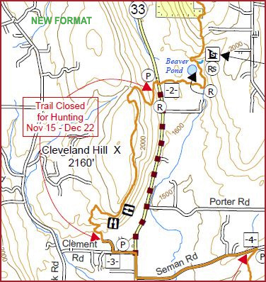
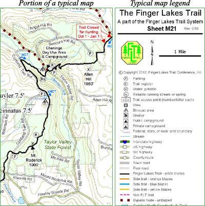
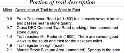
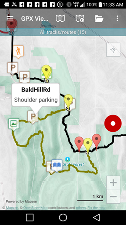
This is an overview map of the Finger Lakes Trail System. It shows tracks of the main trail, branch trails, loops and spurs. The track colors represent the blaze colors for the branch trails, loops, spurs, and sections of the main FLT not blazed in white.  Most of the main FLT is depicted in black & white for better visibility on various map backgrounds, but blazed in white on the ground. Trail closures (hunting, logging, etc.) and recommended bypass routes are depicted as shown at right. Hover over a track to display the name and length. Tracks colored magenta and labeled “Non-FLT” show approximate location only and may not represent the condition and location of the trail on the ground. 

When you zoom in on a trail section, trailheads, notices, and important infrastructure such as lean-tos are also shown.

  • Pan and zoom with the mouse or by using the controls in the upper left corner.
  • Control the map background using the controls in the upper right corner.
  • Click on trail icons for more information about the feature.
  • Click on the main trail and branch tracks to display an elevation profile of that section of the trail.

Symbols and tools

HamburgerMenu.jpg Click the menu button in the upper right for commands to Change the map background and Adjust map opacity,
geolocateme.gif Click the button in the upper right to view the map in the full window. Then click the geolocate button to show your present GPS location on the map.
The following symbols appear on the map (use the Hide/Show Symbols menu in the upper right to control symbol visibility):
flticon.gif Information about FLTC Maps, flticonLoop.gif Loop Maps, Guides and GPS files you can purchase from the FLTC Store.
Also, connect to Trail Condition Notices directly from the flticon.gif symbols.
Trailhead with parking. Click the symbol for more information and for driving directions.
Parking prohibited by law or landowner request.
Parking Advisory – Limited or poor parking; some have nearby alternatives.
Campground.png Camping, including lean-tos, bivouac sites, public and private campgrounds. See Lean-tos, Bivouac Areas, and Campgrounds for more information
Flag_Red.png Hunting closures. See Hunting Season Schedules for more information.
WaterPotable.png Potable water
WaterUntreated.jpg Water source – TREAT BEFORE DRINKING
Passport hike FLT Passport hike is nearby. Click the icon to view details, obtain a map, or obtain the guidebook.
Street view Google street view. Drag the icon onto highlighted streets and click. (For more information)
½-mile tickmark – hover over a tickmark to display the mileage along the trail segment (Use Hide/Show Symbols menu to show the tickmarks).
NavaidViolet.gif Connections to other long-distance hiking trails.
map_recentertool.jpg Enter GPS coordinates (Latitude, Longitude) or an address (street address, town, or zip code) and click Find to recenter the map at that location.
map_centertool.jpg Click on the center tool to show a small cross-hair in the center of the map. The tool shows the coordinates of the center if you pan or scroll the map.

How to use this map

The interactive maps may not display correctly with Internet Explorer. For best results, use Firefox, Chrome, Edge, or Safari. If you have a fast computer and fast network connection, you can try the unsegmented Full System version of the map here.

Map_Legend.jpgThis is a overview map of the Finger Lakes Trail System. It shows tracks of the main trail, branch trails, loops and spurs. The track colors represent the blaze colors for the branch trails, loops, spurs, and sections of the main FLT not blazed in white.  Most of the main FLT is depicted in black & white for better visibility on various map backgrounds, but blazed in white on the ground. Trail closures (hunting, logging, etc.) and recommended bypass routes are depicted as shown at right. Hover over a track to display the name and length. Tracks colored magenta and labeled “Non-FLT” show approximate location only and may not represent the condition and location of the trail on the ground. 

When you zoom in on a trail section, trailheads, notices, and important infrastructure such as lean-tos are also shown.

  • Pan and zoom with the mouse or by using the controls in the upper left corner.
  • Control the map background using the controls in the upper right corner.
  • Click on trail icons for more information about the feature.
  • Click on the main trail and branch tracks to display an elevation profile of that section of the trail.

Symbols and tools

HamburgerMenu.jpg Click the menu button in the upper right for commands to Change the map background and Adjust map opacity,
geolocateme.gif Click the button in the upper right to view the map in the full window. Then click the geolocate button to show your present GPS location on the map.
The following symbols appear on the map (use the Hide/Show Symbols menu to control symbol visibility):
flticon.gif Click for information about FLTC Maps, flticonLoop.gif Loop Maps, Guides and GPS files you can purchase from the FLTC Store. Gray rectangles show the coverage area of each map. Also, connect to Trail Condition Notices directly from the flticon.gif symbols.
Trailhead with parking. Click the symbol for more information. GPS coordinates, and for driving directions.
  Parking prohibited by law or landowner request.
Parking Advisory – Limited or poor parking; some have nearby alternatives.
Campground.png Camping: lean-tos, bivouacs, public and private campgrounds. See Lean-tos, Bivouacs, and Campgrounds for more information
Flag_Red.png Hunting closures. See Hunting Season Schedules for more information.
WaterPotable.png Potable water     WaterUntreated.jpg Water source – TREAT BEFORE DRINKING
½-mile tickmark – hover over a tickmark to display the mileage along the trail segment (Use Hide/Show Symbols menu to show the tickmarks).
NavaidViolet.gif Connections to other long-distance hiking trails.
searchbox.jpg Enter GPS coordinates (Latitude, Longitude) or an address (street address, town, or zip code) and click Find to recenter the map at that location.
map_centertool.jpg Click on the center tool to show a small cross-hair in the center of the map. The tool shows the latitude and longitude coordinates of the center if you pan or scroll the map.
GPSVMenu.jpg Select a map background from the list in the upper right. Use the menu icons to find tools to measure distance and control background opacity.
Section Maintainer

As a trail Section Maintainer (called Steward or Adopter by some clubs) you assume responsibility for a section of the Finger Lakes Trail, generally 1 or 2 miles in length. Working for your club or trail sponsoring organization, or as an individual trail sponsor under one of the FLTC’s volunteer Regional Trail Coordinators, you agree to visit your section three times per year. You perform routine inspection and maintenance: clear vegetation and fallen branches, pickup litter, refresh blazes and signs as needed, check up on trail infrastructure such as register boxes, benches, bridges, lean-tos, etc.

To access the services of a roving certified chainsaw operator or for anything else you can’t handle yourself, you will contact your club or organization’s trails chairperson, or the FLTC’s Regional Trail Coordinator who oversees your area. They will help you organize a work day with a local work crew.

You will keep a log of your activities and report total hours of trail work, drive time, and administrative work, and report it to your trails chairperson or sponsor.

You will also be invited to attend occasional training meetings in your region.

Report Trail Conditions

Since our volunteer trail maintainers don’t visit the trail every day, we depend on you to notice and report trail conditions that need to be corrected. It could be a safety issue or just an inconvenience, but let us know about it. On the other hand, remember that the Finger Lakes Trail is a “primitive footpath” so that some conditions such as a steep rocky section, an occasional “step-over” log, or a section that is muddy in some seasons, are a natural part of the experience.

Please submit your trail condition reports by e-mail at [email protected]. If you do not have e-mail, call the FLT Service Center in Mount Morris at (585)658-9320. During times when the office is not open, please leave a voice message with a daytime phone number where we can reach you for more information.

Describe the problem clearly, being as specific as possible as to the location and nature of the problem. Include as much of the following as possible:

  • Town, County, public land name (State Forest, etc.)
  • FLTC map number(s) – You can find map numbers on the Interactive Map; zoom into the problem area and click on the nearest flticon.gif icon.
  • Access points, distance from road crossings, trail mileage, or GPS coordinates
  • Direction of travel if important in observing the problem (such as blazing).

Give your best estimate of what is needed to correct the problem; we hate to send a crew with chainsaws only to find a small tree that could have been handled by one person with a handsaw.

chainsaw_2156a.jpg
FLTC volunteers attend 2-day training course in safe and efficient use of chainsaws for clearing blowdown
on the Finger Lakes Trail – Photo R. Hopkins

How to use this map

The interactive maps may not display correctly with Internet Explorer. For best results, use Firefox, Chrome or Safari.

Map_Legend.jpgThis is an overview map of the portion of the North Country National Scenic Trail carried on the Finger Lakes Trail System. It shows only the main route of the NCNST; branches, loops, and spurs are not shown. The main FLT trail section is depicted in black for better visibility on various map backgrounds, but blazed in white on the ground. The Onondaga Trail section is depicted in blue and blazed in blue. Trail closures (hunting, logging, etc.) and recommended bypass routes are depicted as shown at right.

When you zoom in on a trail section, trailheads, notices, and important infrastructure such as lean-tos are also shown.

  • Pan and zoom with the mouse or by using the controls in the upper left corner.
  • Control the map background using the controls in the upper right corner.
  • Click on trail icons for more information about the feature.
  • Click on the trail to display an elevation profile of that section of the trail.

Symbols and tools

HamburgerMenu.jpg Click the menu button in the upper right for commands to Change the map background and Adjust map opacity,
geolocateme.gif Click the button in the upper right to view the map in the full window. Then click the geolocate button to show your present GPS location on the map.
The following symbols appear on the map (use the Hide/Show Symbols menu to control symbol visibility):
flticon.gif Click for information about FLTC Maps, flticonLoop.gif Loop Maps, Guides and GPS files you can purchase from the FLTC Store. Gray rectangles show the coverage area of each map. Also, connect to Trail Condition Notices directly from the flticon.gif symbols.
Trailhead with parking. Click the symbol for more information. GPS coordinates, and for driving directions.
NoParking.gif Parking prohibited by law or landowner request.
Campground.png Camping: lean-tos, bivouacs, public and private campgrounds. See Lean-tos, Bivouacs, and Campgrounds for more information
Flag_Red.png Hunting closures. See Hunting Season Schedules for more information.
WaterPotable.png Potable water     WaterUntreated.jpg Water source – TREAT BEFORE DRINKING
½-mile tickmark – hover over a tickmark to display the mileage along the trail segment (use Hide/Show Symbols menu to show the tickmarks)
NavaidViolet.gif Connections to other long-distance hiking trails.
searchbox.jpg Enter GPS coordinates (Latitude, Longitude) or an address (street address, town, or zip code) and click Find to recenter the map at that location.
map_centertool.jpg Click on the center tool to show a small cross-hair in the center of the map. The tool shows the latitude and longitude coordinates of the center if you pan or scroll the map.
GPSVMenu.jpg Select a map background from the list in the upper right. Use the menu icons to find tools to measure distance and control background opacity.

Current members of the Finger Lakes Trail are entitled to discounts on maps, stickers, and patches for sale on this website. A member coupon code is also provided for clothing and logo merchandise on the third-party website.

If your membership is current, you should see the symbol on discounted products. If you do not see this, please add this ($0.00) product to your EMPTY shopping cart. Then checkout. Log out of the website, log back in, and return to the store. You should now see the discount symbol and see discounted prices on your purchases.

Paper map example

Download a sample paper map in PDF form here.

The following are examples from a typical map:
newmap.jpg typical_map1.jpg typical_map2.jpg

Former Board Members

CLASS OF 2024 CLASS OF 2023
Ann Bayley Donna Flood
Lisette Brennan Sharon Ray
Christine DeGolyer Willa Powell
Tim Holahan
Terry Meacham
CLASS OF 2022 CLASS OF 2021 CLASS OF 2020
Peg Fuller Ann Bayley Donna Flood
Scott Geiger Rich Breslin Laurie Ondrejka
Roger Hopkins Scott Brooks Mike Ogden
Tim Sweeney Terry Meacham Dave Newlun
Peter Wybron
CLASS OF 2019 CLASS OF 2018 CLASS OF 2017
Roger Hopkins Scott Brooks Michael Ogden
Tim Sweeney* Bob Kremens Debra Nero
David Tuttle Terry Meacham Sieglinde Schwinge
Laurie Ondrejka Wendy Stevenson
Anna Keeton* Donna Flood*
CLASS OF 2016 FUN CLASS OF 2015 CLASS OF 2014
Cate Concannon Scott Brooks Scott Bahantka
David Drum Donna Coon* Jon Bowen
Donna Flood Roger Hopkins Donna Cole
Roger Hopkins* Terry Meacham Melanie Okoniewski
David Tuttle Laurie Ondrejka Sigi Schwinge
CLASS OF 2013 CLASS OF 2012 CLASS OF 2011
Cathy Concannon Patricia Haynes Jon Bowen
Phil Dankert Roger Hopkins Bill Coffin
David Drum Phil Metzger Terry Meacham
Donna Flood John A-X Morris Ray Recchia
Gail Merian Ken Reek Sigi Schwinge
CLASS OF 2010 CLASS OF 2009 CLASS OF 2008
Phil Dankert Richard Breslin Dawn Bennett
Cheryl Peluso Vicky Gaeta Linda Cruttenden
Georgeanne Vyverberg John A-X. Morris Scott Lauffer
George Zacharek Irene Szabo Terry Meacham
Jacqui Wensich
WordPress Table

*Appointed

The FLTC offers downloadable files containing complete track and complete waypoint GPS data detailing all of the approximately 1,000 miles of the FLT, including main, loop, branch, and spur trails. In addition to GPS data, the downloadable files contain PDF images of the paper maps. GPS data is in the form of GPX files that can be loaded onto smart phones supporting GPX apps.

GPX Viewer and GPX Viewer Pro for Android devices

The free GPX Viewer from Vectura will enable you to view our maps on your Android phone. Tracks and waypoints are displayed on a variety of on-line map backgrounds along with your present location.

GPX Viewer Pro (license fee) has all of the features of GPX Viewer plus you can record the track of your hike. You can also download background maps to your device that can be viewed during your hike even if you have no cell phone coverage.

If you have experience using other smart phone apps, please let us know at [email protected].

Using GPX files on GPS units

The FLTC offers downloadable files containing complete track and complete waypoint GPS data detailing all of the approximately 1,000 miles of the FLT, including main, loop, branch, and spur trails. In addition to GPX data, the downloadable files contain PDF images of the paper maps. GPX files can be loaded onto color “field” (i.e. hiking, as opposed to automotive) GPS units. These GPX files can also be opened in Google Earth, so that you can view your hikes ahead of time (you can download the necessary software from Google Earth for free).

Detailed instructions for using the Track and Waypoint data in these GPX files are provided here.

Notes on Garmin units

Instructions for using the data with these recommended Garmin GPS units are also included:

Recent Garmin units: 62, 78, Oregon, Dakota, and Colorado. The Oregon and Dakota models are “touch screen” units (similar to auto GPS units) amd may be a little easier to learn how to use.

  • Advantages: Can hold 200 loaded (saved) tracks of up to 10,000 track points each, slicker interfaces to work with, can load in aerial imagery (Google Earth in your hand) at $30/year.
  • Disadvantages: More expensive, loaded (saved) tracks do not retain track colors and are not turned on by default (but we’re hoping a future update with Garmin WebUpdater will fix these two problems).

Older Garmin units: 60, 78 (instructions can also be used with Etrex Vista HCx and Etrex Legend HCx with slight modifications).

  • Advantages: Less expensive, loaded (saved) tracks retain track colors and are turned on by default.
  • Disadvantages: Can hold only 20 loaded (saved) tracks of only 500 track points each (but tracks we sell are filtered down to this level), these models may soon be discontinued, Etrex models mentioned above can be quite inaccurate if oriented vertically.

Bottom Line Recommended Unit?  If you are a “techie” and can find it, grab the 60CSx at the present discounted prices.  If you are a “newbie” you might prefer the touch screen Dakota or Oregon units (the Oregon 550 models can also take geotagged [lat-long embedded] photos).

Unless you have one of the recent Garmin units that has preloaded topo maps (indicated with a “t” at the end of the model number) you will want to download free topo maps for Garmin GPS units from GPS File Depot or other web sites. You can also purchase Garmin Topo U.S. 100K  or similar Garmin software on DVD or micro SD card, but these can be expensive.

NOTES ON OTHER GPS BRANDS

Delorme Units: These data also work with the Delorme GPS units PN-20 and PN-40, if you also have Delorme Topo software. However, expect loss of track and waypoint attributes (such as colors and symbols) with these and other GPS units that are not in the above recommended list.

Other Units: These GPX files may be compatible with other GPS units, but we have tested these files only with the recommended units listed above. If you are using another unit, it is up to you to determine that your GPS unit can use this GPX data. Before ordering the digital download map files, try downloading this sample GPX file, M09.gpx (our map M9), to ensure that it is compatible with your hardware and software.

As a Local Work Crew member you will join other volunteers recruited to work on trail projects that are beyond routine maintenance and the capabilities of the individual trail section adopter/steward. Projects might be repairing trail erosion, clearing downed trees, repairing bridges and structures, and the like. Projects are usually one day or less. Work parties are typically organized by the club or organization sponsoring the section or by the FLTC’s Regional Trail Coordinator for the area.

Many of our Local Work Crew members also have their own trail section they maintain.

Trail work projects are announced by e-mail and by local websites and newsletters. Let your trails chairperson, trail sponsor, or regional trail coordinator know if you will join the crew as this will greatly help with planning.

Your trails chairperson, trail sponsor, or regional trail coordinator will be responsible for reporting total hours of trail work, drive time, and administrative time.

To join your local trail work crew, simply contact your trails chairperson, trail sponsor, or regional trail coordinator and get your name on the distribution list.

Scroll to top