Listed West to East; Table updated Sept 13, 2022. Please report any issues.
Large scale maps (with detailed mileage descriptions) are available in PDF or Paper form for Loops shown in bold.
All loops are shown on the parent maps in PDF, Paper, GPX, and Interactive Map formats.
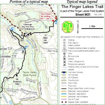
Some FLTC maps may show non-FLT trails with special coloring or style. Those trails are not maintained by the FLTC and their condition and location must be determined through other sources.
| Loop Trail Name | Located on Map(s) [AP = Access Point] |
Full Loop** Length in Miles |
Blaze Color Loop Trail/Linear Trail |
|---|---|---|---|
| Cobb 45 Blue / Yellow Loops | M4, access at NY Route 242, around loop and back. New yellow blazed trail provides additional .33 mile section. | 1.7 | Blue/White, Yellow |
| Robinson Loops | M8, various loops possible at near Swain | 1.2 to 10+ | Blue, Orange, Yellow/White |
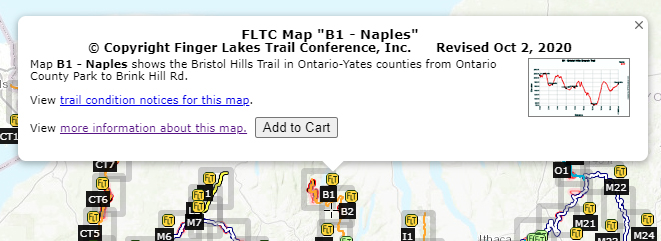
| High Tor Loop (other loops possible; see map B1) | B1, at AP 5D to AP 5A, AP 5C, AP 6A, and back to 5D | 4.8 | Blue/Orange |
| Huckleberry Bog Nature Trail (Map HBL) | B3, at AP 16 , around loop, and back to AP 16 | 4.5 | Blue/Orange |
| Pinnacle State Park-McCarthy Hill State Forest Loops (Map PMHL) | CH2, various loops possible at Pinnacle S. P. | 1.0 to 20+ | Blue, Yellow, Green, Red/Orange |
| Queen Catharine Marsh Loop (Map QC) | QCMLT, access at Watkins Glen State Park (M15) | 8.1 | Orange/White |
| Montour Falls Historic Loop Map MF) | MFHLT, access at Catharine Valley Trail, which will connect to Queen Catharine Marsh Loop Trail near south end of Barge Canal. | 5.5 | Orange/White |
| Texas Hollow Loop | M15, access at Texas Hollow Road | 1.3 | Blue/White |
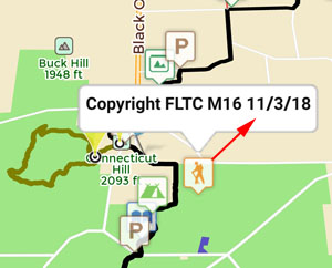
| Van Lone Hill Loop | M16, access at Gulf Road just East of CR 6 or at Todd Road | 5.8 | Orange/White |
| Bob Cameron Loop | M16, access at Tower Road | 2.8 | Orange/White |
| Upper Robert Treman State Park Loop | M16, access at Old Mill in upper Robert Treman S. P. | 1.5 | Blue/White |
| Abbott Loop (Map AL) | M17, access at Michigan Hollow Road | 8.3 | Orange/White |
| Spanish Loop and Irvin Trail (Map SpL) | M19, access at Daisy Hollow Road south trailhead | 6.1 | Orange/Blue/White |
| Swedish Loop (Map SwL) | M19, access at Daisy Hollow Road north trailhead | 5.2 | Blue/White |
| International Loop (Map InL-Combined Spanish and Swedish Loops) | M19, access at Daisy Hollow Road north trailhead | 7.2 | Blue/Orange/White |
| International Loop Two (Map InL2 – Combined Lithuanian and Irish Loops) | M19, access at Babcock Hollow Road | 2.4 | Yellow/Green |
| Dabes Diversion Loop (Map VML) | M19, access at Bleck Road (2 places) | 4.2 (3.1 if using Kuzia Cutoff) | Orange/White/(Blue) |
| Virgil Mt. Loop (Map VML) | M19, access at O’Dell Road | 4.8 (9.0 with above loop) | Orange/White |
| Woodchuck Hollow Lean-to Loop | M20, access at Cortland 9 DEC Truck Road | 1.2 | Blue/White |
| Fellows Hill Loop | O1, access at Herlihy Road (2 places) | 3.1 | Orange |
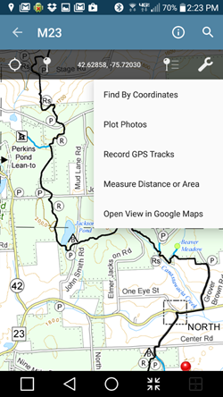
| Plymouth Lean-to Loop | M23, access at Stewart Road or Chenango 5 Truck Road | 6.4 | Blue/White |
| Kopac Loop, including out and back to Whaley Pond | M24, access at Bowman Lake State Park | 3.8 | Blue/White |
| Little Pond State Campgound Loop | M31, access at Little Pond DEC State Campgound | 3.0 | Yellow/Red/Blue Disks |
| ** Full Loop length includes both loop trail, linear trail, and any out & back miles from the suggested parking. | |||
Spur Trails of the Finger Lakes Trail System
Listed West to East; More than 1 mile in length, one way*
Table updated Dec. 27, 2011
| Spur Trail Name | Located on Map(s) [AP = Access Point] |
One Way Length in Miles |
Blaze Color |
|---|---|---|---|
| Allegany Administration Building Spur | M1, access in State Park at administration building | 2.2 | Blue |
| Kanakadea Lean-to Spur | M9, access at Webb Road | 2.0 | Blue |
| Hi Tor Blue Trail (can be used for loops with orange trail) | B1, access at AP 5D or AP 6 | 4.7 | Blue |
| June Bug Trail | M12, access at Glenn Curtis Air Museum or main FLT | 1.2 | Blue |
| Buttermilk Falls State Park Spur | M17, access at Sandbank Rd. or Buttermilk Falls S. P. | 2.2 | Orange |
| Chippewa Falls Spur | M22, access at Stoney Brook Road | 1.5 | Orange |
| Oquaga Creek State Park Spur | M27, access at Oquaga State Park or main FLT | 2.2 | Blue |
| *Other short side trails, less than 1 mile and generally blazed blue, are used for access to major trails, water sources, shelters, and campsites. | |||


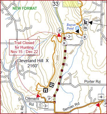
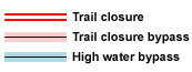 This is an overview map of the Finger Lakes Trail System. It shows tracks of the main trail, branch trails, loops and spurs. The track colors represent the blaze colors for the branch trails, loops, spurs, and sections of the main FLT not blazed in white. Most of the main FLT is depicted in black & white for better visibility on various map backgrounds, but blazed in white on the ground. Trail closures (hunting, logging, etc.) and recommended bypass routes are depicted as shown at right. Hover over a track to display the name and length. Tracks colored
 This is a overview map of the Finger Lakes Trail System. It shows tracks of the main trail, branch trails, loops and spurs. The track colors represent the blaze colors for the branch trails, loops, spurs, and sections of the main FLT not blazed in white. Most of the main FLT is depicted in black & white for better visibility on various map backgrounds, but blazed in white on the ground. Trail closures (hunting, logging, etc.) and recommended bypass routes are depicted as shown at right. Hover over a track to display the name and length. Tracks colored